
Haz una donación
Mapa topográfico Worcester County
Haga clic en el mapa para ver la altitud.
Haz una donación
Worcester County
The terrain is mostly level and coastal. The lowest elevation is sea level along the Atlantic Ocean and the highest elevation is 49 ft (15 m) in the northwestern part of the county along State Route 12 just south of the Wicomico County line.
Haz una donación
Acerca de este mapa
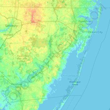
Nombre: Mapa topográfico Worcester County, altitud, relieve.
Lugar: Worcester County, Maryland, United States (37.99428 -75.66177 38.45204 -74.98520)
Altitud media: 6 m
Altitud mínima: -3 m
Altitud máxima: 28 m
Haz una donación
Otros mapas topográficos
Haga clic en un mapa para ver su topografía, su altitud y su relieve.
Baltimore
Baltimore exhibits a diverse topography that plays a significant role in its character and development. Situated along the Patapsco River, which flows into the Chesapeake Bay, the city is positioned on the fall line that separates the Piedmont Plateau to the west from the Atlantic Coastal Plain to the east.…
Altitud media: 65 m
Upper Marlboro
United States > Maryland > Prince George's County > Upper Marlboro > Upper Marlboro
Altitud media: 27 m
Haz una donación
Haz una donación
Haz una donación
Haz una donación
Zihlman
United States > Maryland > Allegany County
Zihlman is located along Maryland Route 36, 1.5 miles (2.4 km) northeast of and 500 feet (150 m) lower in elevation than Frostburg. Mount Savage is 3 miles (5 km) further northeast along MD 36.
Altitud media: 590 m
Haz una donación
Haz una donación
Haz una donación
Haz una donación
Haz una donación
Lavale Community Park
United States > Maryland > Allegany County > Allegany Grove
Altitud media: 354 m
Haz una donación
Haz una donación
Haz una donación
Haz una donación
Haz una donación
Haz una donación
Haz una donación
Haz una donación
Haz una donación
Haz una donación
Haz una donación
Haz una donación
Haz una donación
Haz una donación
Haz una donación
Dundalk
United States > Maryland > Baltimore County
Most of Dundalk is flat and very near sea level, with a few small hills close to the city of Baltimore to the west. Dundalk is part of the Atlantic Coastal Plain. Elevations range from sea level on the shore of the Chesapeake Bay to approximately 40 feet (12 m) above sea level along the northern reaches of…
Altitud media: 33 m
Haz una donación