
Gracias por apoyar a este sitio ❤️
Haz una donación
Haz una donación
Mapa topográfico Magothy Forest
Haga clic en el mapa para ver la altitud.
Gracias por apoyar a este sitio ❤️
Haz una donación
Haz una donación
Acerca de este mapa
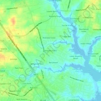
Nombre: Mapa topográfico Magothy Forest, altitud, relieve.
Altitud media: 13 m
Altitud mínima: -3 m
Altitud máxima: 35 m
Gracias por apoyar a este sitio ❤️
Haz una donación
Haz una donación
Otros mapas topográficos
Haga clic en un mapa para ver su topografía, su altitud y su relieve.
Magothy River
United States > Maryland > Anne Arundel County > Severna Park
Almost all of the creeks and tidal coves on the Magothy are named, partly as the result of a project started in 2001 by the Magothy River Association. They are shown on a map produced as part of that project, and the major ones are shown on the USGS topographic map.
Altitud media: 9 m