
Haz una donación
Mapa topográfico Dundalk
Haga clic en el mapa para ver la altitud.
Haz una donación
Dundalk
Most of Dundalk is flat and very near sea level, with a few small hills close to the city of Baltimore to the west. Dundalk is part of the Atlantic Coastal Plain. Elevations range from sea level on the shore of the Chesapeake Bay to approximately 40 feet (12 m) above sea level along the northern reaches of Dundalk Avenue and North Point Boulevard.
Haz una donación
Acerca de este mapa
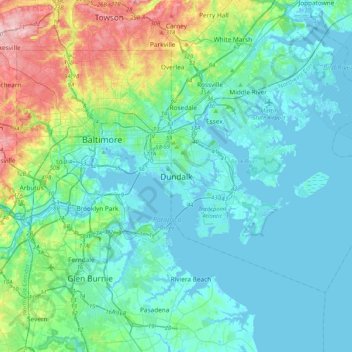
Nombre: Mapa topográfico Dundalk, altitud, relieve.
Lugar: Dundalk, Baltimore County, Maryland, 21222, United States (39.09741 -76.68367 39.41741 -76.36367)
Altitud media: 33 m
Altitud mínima: -3 m
Altitud máxima: 173 m
Haz una donación
Otros mapas topográficos
Haga clic en un mapa para ver su topografía, su altitud y su relieve.
Haz una donación
Soldiers Delight Natural Environment Area
United States > Maryland > Baltimore County > Owings Mills
Altitud media: 187 m
Haz una donación
Haz una donación