
Haz una donación
Mapa topográfico Zihlman
Haga clic en el mapa para ver la altitud.
Haz una donación
Zihlman
Zihlman is located along Maryland Route 36, 1.5 miles (2.4 km) northeast of and 500 feet (150 m) lower in elevation than Frostburg. Mount Savage is 3 miles (5 km) further northeast along MD 36.
Haz una donación
Acerca de este mapa
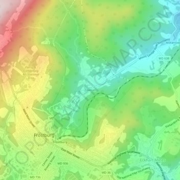
Nombre: Mapa topográfico Zihlman, altitud, relieve.
Lugar: Zihlman, Allegany County, Maryland, 21528, United States (39.64814 -78.93502 39.68814 -78.89502)
Altitud media: 590 m
Altitud mínima: 425 m
Altitud máxima: 846 m
Haz una donación
Otros mapas topográficos
Haga clic en un mapa para ver su topografía, su altitud y su relieve.
Shaft
United States > Maryland > Allegany County > Borden Shaft > Braddock Estates
Shaft is a census-designated place (CDP) corresponding to the unincorporated community of Borden Shaft in Allegany County, Maryland, United States. As of the 2010 census, the CDP had a population of 235. It is located south of Frostburg, in the Georges Creek Valley. It lies at an elevation of 1,795 feet (547…
Altitud media: 588 m
Lavale Community Park
United States > Maryland > Allegany County > Allegany Grove
Altitud media: 354 m
Haz una donación
Rawlings
United States > Maryland > Allegany County > Rawlings > Rawlings Heights
Altitud media: 262 m
Haz una donación
County Fairgrounds
United States > Maryland > Allegany County > Potomac Park > Cedar Cliff
Altitud media: 274 m
Haz una donación