
Haz una donación
Mapa topográfico Baltimore
Haga clic en el mapa para ver la altitud.
Haz una donación
Baltimore
Baltimore exhibits a diverse topography that plays a significant role in its character and development. Situated along the Patapsco River, which flows into the Chesapeake Bay, the city is positioned on the fall line that separates the Piedmont Plateau to the west from the Atlantic Coastal Plain to the east. This geographic setting results in varying elevations, with the harbor area at sea level and some neighborhoods reaching heights of approximately 480 feet (150 meters) in the northwest, particularly near Pimlico. The terrain features rolling hills and valleys, contributing to the city's scenic vistas and the fertile land that supports urban green spaces. Overall, Baltimore's topography combines urban development with natural landscapes, creating a unique environment that reflects both its historical significance and modern character.
Haz una donación
Acerca de este mapa
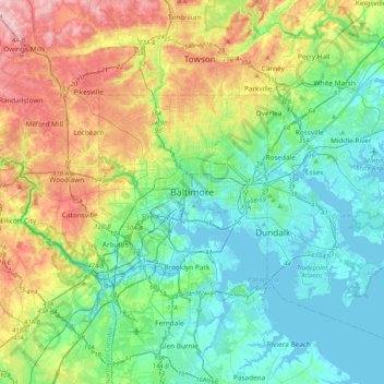
Nombre: Mapa topográfico Baltimore, altitud, relieve.
Lugar: Baltimore, Maryland, 21233, United States (39.13088 -76.77076 39.45088 -76.45076)
Altitud media: 65 m
Altitud mínima: -5 m
Altitud máxima: 219 m
Haz una donación
Otros mapas topográficos
Haga clic en un mapa para ver su topografía, su altitud y su relieve.
Chesapeake Bay
Tides in the Chesapeake Bay exhibit an interesting and unique behavior due to the nature of the topography (both horizontal and vertical shape), wind-driven circulation, and how the Bay interacts with oceanic tides. Research into the peculiar behavior of tides both at the northern and southern extents of the…
Altitud media: 33 m
Haz una donación
Worcester County
The terrain is mostly level and coastal. The lowest elevation is sea level along the Atlantic Ocean and the highest elevation is 49 ft (15 m) in the northwestern part of the county along State Route 12 just south of the Wicomico County line.
Altitud media: 6 m
Haz una donación
Shaft
United States > Maryland > Allegany County > Borden Shaft > Braddock Estates
Shaft is a census-designated place (CDP) corresponding to the unincorporated community of Borden Shaft in Allegany County, Maryland, United States. As of the 2010 census, the CDP had a population of 235. It is located south of Frostburg, in the Georges Creek Valley. It lies at an elevation of 1,795 feet (547…
Altitud media: 588 m
Haz una donación
Assateague State Park
United States > Maryland > Worcester County > Berlin > Golf Club Shores
Altitud media: 1 m
Franklin Point State Park
United States > Maryland > Anne Arundel County > Columbia Beach
Altitud media: 1 m
Lavale Community Park
United States > Maryland > Allegany County > Allegany Grove
Altitud media: 354 m
Haz una donación
Haz una donación
Haz una donación
Haz una donación
Haz una donación
Haz una donación
Haz una donación
Haz una donación
Rawlings
United States > Maryland > Allegany County > Rawlings > Rawlings Heights
Altitud media: 262 m
Darlington
United States > Maryland > Harford County > Darlington > Hopkins Corner
Altitud media: 88 m
Haz una donación
Chapman State Park
United States > Maryland > Charles County > Indian Head > Chapman Landing
Altitud media: 19 m
Haz una donación
Haz una donación
Crisfield
United States > Maryland > Somerset County
Crisfield is a very compact city, with little vacant land. According to the United States Census Bureau, the city has a total area of 3.06 square miles (7.93 km2), of which 1.62 square miles (4.20 km2) (53.0%) is land and 1.44 square miles (3.73 km2) (47.0%) is water. As one of the southern points on the…
Altitud media: 1 m
Haz una donación
Haz una donación
Monocacy River
United States > Maryland > Frederick County > Bartonsville > Pine Cliff
Altitud media: 97 m
University Park
United States > Maryland > Prince George's County > University Park
University Park was developed on land owned by the Deakins family since the mid-1700s. The house known as Deakins Hall or Bloomfield was constructed on the land in the 1820s or 1830s. It is located at 6404 Queens Chapel Road. The farm was purchased by the University Park Company in 1923. The extension of water…
Altitud media: 29 m
Haz una donación
Aberdeen Proving Ground
United States > Maryland > Harford County > Aberdeen Proving Ground
Altitud media: 7 m
Haz una donación
Haz una donación
Magothy River
United States > Maryland > Anne Arundel County > Severna Park
Almost all of the creeks and tidal coves on the Magothy are named, partly as the result of a project started in 2001 by the Magothy River Association. They are shown on a map produced as part of that project, and the major ones are shown on the USGS topographic map.
Altitud media: 9 m
Haz una donación
Haz una donación
Cape St. Claire
United States > Maryland > Anne Arundel County > Cape Saint Claire
Altitud media: 12 m
Haz una donación
County Fairgrounds
United States > Maryland > Allegany County > Potomac Park > Cedar Cliff
Altitud media: 274 m
Haz una donación
Haz una donación
Haz una donación