
Haz una donación
Mapa topográfico Bel Air
Haga clic en el mapa para ver la altitud.
Haz una donación
Acerca de este mapa
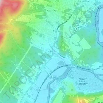
Nombre: Mapa topográfico Bel Air, altitud, relieve.
Lugar: Bel Air, Allegany County, Maryland, United States (39.55315 -78.86974 39.59315 -78.82974)
Altitud media: 263 m
Altitud mínima: 193 m
Altitud máxima: 523 m
Haz una donación
Otros mapas topográficos
Haga clic en un mapa para ver su topografía, su altitud y su relieve.
Shaft
United States > Maryland > Allegany County > Borden Shaft > Braddock Estates
Shaft is a census-designated place (CDP) corresponding to the unincorporated community of Borden Shaft in Allegany County, Maryland, United States. As of the 2010 census, the CDP had a population of 235. It is located south of Frostburg, in the Georges Creek Valley. It lies at an elevation of 1,795 feet (547…
Altitud media: 588 m
Lavale Community Park
United States > Maryland > Allegany County > Allegany Grove
Altitud media: 354 m
Haz una donación
Rawlings
United States > Maryland > Allegany County > Rawlings > Rawlings Heights
Altitud media: 262 m
Haz una donación
County Fairgrounds
United States > Maryland > Allegany County > Potomac Park > Cedar Cliff
Altitud media: 274 m
Haz una donación