
Haz una donación
Mapa topográfico Bay Minette
Haga clic en el mapa para ver la altitud.
Haz una donación
Acerca de este mapa
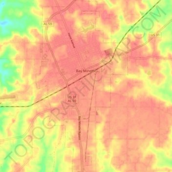
Nombre: Mapa topográfico Bay Minette, altitud, relieve.
Lugar: Bay Minette, Baldwin County, Alabama, 36507, United States (30.83679 -87.79971 30.91506 -87.75079)
Altitud media: 72 m
Altitud mínima: 26 m
Altitud máxima: 90 m
Haz una donación
Otros mapas topográficos
Haga clic en un mapa para ver su topografía, su altitud y su relieve.
Gulf Shores
United States > Alabama > Baldwin County
Jack Edwards National Airport is located in Gulf Shores and offers services from Gulf Air Center, Salt Air Aviation Center and Platium Air Center. The airport is located in town, two miles from the beach. Their FBO Gulf Air Center will provide a rental vehicle while they take care of fueling and storing…
Altitud media: 5 m
Daphne
United States > Alabama > Baldwin County
The topography of Daphne is quite consistent from a gently sloping sea level on the west to low rolling hills further east. Generally, the entire city lies no more than 150 feet above sea level. The land along the Daphne bay coast, like other land throughout the county, is rich with sandy-loam type soils.
Altitud media: 25 m
Haz una donación
Haz una donación
Fairhope
United States > Alabama > Baldwin County
According to the U.S. Census Bureau, the city has a total area of 12.0 square miles (31.1 km2), of which 0.019 square mile (0.05 km2), or 0.16%, is water. Its elevation ranges from sea level at the bay to 122 feet (37 m) in the city center.
Altitud media: 17 m
Haz una donación
Summerdale
United States > Alabama > Baldwin County
The Navy Outlying Landing Field (NOLF) Summerdale airport is on the east side of Summerdale (at latitude, longitude: 30.507695, –87.645541). The Airport Code is NFD, in region: ASO - Southern, with boundary ARTCC: ZJX - Jacksonville, and Tie-in FSS: ANB - Anniston. The airport runway length/width is 2850 x…
Altitud media: 32 m
Daphne
United States > Alabama > Baldwin County
The topography of Daphne is quite consistent from a gently sloping sea level on the west to low rolling hills further east. Generally, the entire city lies no more than 150 feet above sea level. The land along the Daphne bay coast, like other land throughout the county, is rich with sandy-loam type soils.
Altitud media: 25 m
Haz una donación
Fairhope
United States > Alabama > Baldwin County
According to the U.S. Census Bureau, the city has a total area of 12.0 square miles (31.1 km2), of which 0.019 square mile (0.05 km2), or 0.16%, is water. Its elevation ranges from sea level at the bay to 122 feet (37 m) in the city center.
Altitud media: 17 m
Haz una donación
Bon Secour
United States > Alabama > Baldwin County > Bon Secour
Bon Secour lies on the Bon Secour River. Elevation is 10 feet (3.0 m) above sea level. The estuarial river system empties into Bon Secour Bay at Mobile Bay.
Altitud media: 6 m
Summerdale
United States > Alabama > Baldwin County
The Navy Outlying Landing Field (NOLF) Summerdale airport is on the east side of Summerdale (at latitude, longitude: 30.507695, –87.645541). The Airport Code is NFD, in region: ASO - Southern, with boundary ARTCC: ZJX - Jacksonville, and Tie-in FSS: ANB - Anniston. The airport runway length/width is 2850 x…
Altitud media: 32 m
Haz una donación
Haz una donación
Haz una donación
Ono Island
United States > Alabama > Baldwin County
Ono Island was along the boundary of the treaties between France and Spain. In 1813, after protests and attempts at rebellion, President James Monroe seized Spanish lands west of the Perdido River and declared them a part of the Louisiana Purchase of 1803. This set the east end of the Island, Perdido Key, at…
Altitud media: 9 m
Daphne
United States > Alabama > Baldwin County
The topography of Daphne is quite consistent from a gently sloping sea level on the west to low rolling hills further east. Generally, the entire city lies no more than 150 feet above sea level. The land along the Daphne bay coast, like other land throughout the county, is rich with sandy-loam type soils.
Altitud media: 25 m
Haz una donación
Gulf Shores
United States > Alabama > Baldwin County
Jack Edwards National Airport is located in Gulf Shores and offers services from Gulf Air Center, Salt Air Aviation Center and Platium Air Center. The airport is located in town, two miles from the beach. Their FBO Gulf Air Center will provide a rental vehicle while they take care of fueling and storing…
Altitud media: 5 m
Haz una donación
Fairhope
United States > Alabama > Baldwin County
According to the U.S. Census Bureau, the city has a total area of 12.0 square miles (31.1 km2), of which 0.019 square mile (0.05 km2), or 0.16%, is water.[2] Its elevation ranges from sea level at the bay to 122 feet (37 m) in the city center.[11]
Altitud media: 17 m
Haz una donación