
Gracias por apoyar a este sitio ❤️
Haz una donación
Haz una donación
Mapa topográfico Bay Minette
Haga clic en el mapa para ver la altitud.
Gracias por apoyar a este sitio ❤️
Haz una donación
Haz una donación
Acerca de este mapa
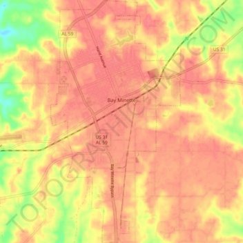
Nombre: Mapa topográfico Bay Minette, altitud, relieve.
Lugar: Bay Minette, Baldwin County, Alabama, 36507, United States (30.78404 -87.86076 30.97094 -87.71675)
Altitud media: 52 m
Altitud mínima: 2 m
Altitud máxima: 91 m
Gracias por apoyar a este sitio ❤️
Haz una donación
Haz una donación
Otros mapas topográficos
Haga clic en un mapa para ver su topografía, su altitud y su relieve.
Gracias por apoyar a este sitio ❤️
Haz una donación
Haz una donación
Gracias por apoyar a este sitio ❤️
Haz una donación
Haz una donación
Ono Island
United States > Alabama > Baldwin County
Ono Island was along the boundary of the treaties between France and Spain. In 1813, after protests and attempts at rebellion, President James Monroe seized Spanish lands west of the Perdido River and declared them a part of the Louisiana Purchase of 1803. This set the east end of the Island, Perdido Key, at…
Altitud media: 9 m
Gracias por apoyar a este sitio ❤️
Haz una donación
Haz una donación
Gracias por apoyar a este sitio ❤️
Haz una donación
Haz una donación