
Haz una donación
Mapa topográfico Fairhope
Haga clic en el mapa para ver la altitud.
Haz una donación
Fairhope
According to the U.S. Census Bureau, the city has a total area of 12.0 square miles (31.1 km2), of which 0.019 square mile (0.05 km2), or 0.16%, is water. Its elevation ranges from sea level at the bay to 122 feet (37 m) in the city center.
Haz una donación
Acerca de este mapa
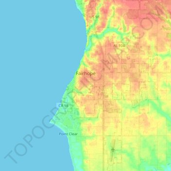
Nombre: Mapa topográfico Fairhope, altitud, relieve.
Lugar: Fairhope, Baldwin County, Alabama, United States (30.44387 -87.92498 30.58224 -87.83542)
Altitud media: 17 m
Altitud mínima: 0 m
Altitud máxima: 49 m
Haz una donación
Otros mapas topográficos
Haga clic en un mapa para ver su topografía, su altitud y su relieve.
Haz una donación
Haz una donación
Ono Island
United States > Alabama > Baldwin County
Ono Island was along the boundary of the treaties between France and Spain. In 1813, after protests and attempts at rebellion, President James Monroe seized Spanish lands west of the Perdido River and declared them a part of the Louisiana Purchase of 1803. This set the east end of the Island, Perdido Key, at…
Altitud media: 9 m
Haz una donación
Haz una donación