
Haz una donación
Mapa topográfico Daphne
Haga clic en el mapa para ver la altitud.
Haz una donación
Daphne
The topography of Daphne is quite consistent from a gently sloping sea level on the west to low rolling hills further east. Generally, the entire city lies no more than 150 feet above sea level. The land along the Daphne bay coast, like other land throughout the county, is rich with sandy-loam type soils.
Haz una donación
Acerca de este mapa
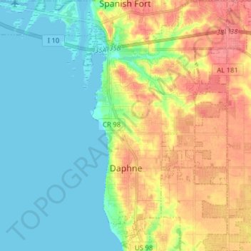
Nombre: Mapa topográfico Daphne, altitud, relieve.
Lugar: Daphne, Baldwin County, Alabama, 36526, United States (30.56731 -87.92522 30.67677 -87.80564)
Altitud media: 25 m
Altitud mínima: -2 m
Altitud máxima: 65 m
Haz una donación
Otros mapas topográficos
Haga clic en un mapa para ver su topografía, su altitud y su relieve.
Haz una donación
Haz una donación
Ono Island
United States > Alabama > Baldwin County
Ono Island was along the boundary of the treaties between France and Spain. In 1813, after protests and attempts at rebellion, President James Monroe seized Spanish lands west of the Perdido River and declared them a part of the Louisiana Purchase of 1803. This set the east end of the Island, Perdido Key, at…
Altitud media: 9 m
Haz una donación
Haz una donación