
Haz una donación
Mapa topográfico Sundad
Haga clic en el mapa para ver la altitud.
Haz una donación
Sundad
Sundad is an unincorporated area in the far west of Maricopa County, Arizona, United States, along the border of Yuma County. It has an estimated elevation of 965 feet (294 m) above sea level. It is located north of Agua Caliente and east of Sacation Flats.
Haz una donación
Acerca de este mapa
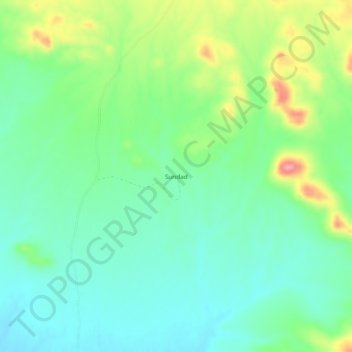
Nombre: Mapa topográfico Sundad, altitud, relieve.
Lugar: Sundad, Maricopa County, Arizona, United States (33.16143 -113.25602 33.20143 -113.21602)
Altitud media: 300 m
Altitud mínima: 266 m
Altitud máxima: 374 m
Haz una donación
Otros mapas topográficos
Haga clic en un mapa para ver su topografía, su altitud y su relieve.
Estrella Mountain Regional Park
United States > Arizona > Maricopa County > Avondale
Altitud media: 397 m
Haz una donación
Haz una donación
Cave Creek Park - Thunderbird
United States > Arizona > Maricopa County > Phoenix
Altitud media: 401 m
Haz una donación
Anthem
United States > Arizona > Maricopa County > Anthem
Anthem is built on 5,856 acres (9.2 sq mi) at the base of Daisy Mountain and Gavilan Peak. The community's elevation ranges from 1,760 feet to 2,428 feet, with an average elevation of 1,863 feet. Approximately 36 percent of the community is preserved as open space, including 291 acres of open hillside.
Altitud media: 580 m
Haz una donación
Haz una donación
Haz una donación