
Gracias por apoyar a este sitio ❤️
Haz una donación
Haz una donación
Mapa topográfico Moeur Park
Haga clic en el mapa para ver la altitud.
Gracias por apoyar a este sitio ❤️
Haz una donación
Haz una donación
Acerca de este mapa
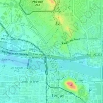
Nombre: Mapa topográfico Moeur Park, altitud, relieve.
Lugar: Moeur Park, Tempe, Maricopa County, Arizona, United States (33.43583 -111.94311 33.43817 -111.94113)
Altitud media: 362 m
Altitud mínima: 341 m
Altitud máxima: 434 m
Gracias por apoyar a este sitio ❤️
Haz una donación
Haz una donación
Otros mapas topográficos
Haga clic en un mapa para ver su topografía, su altitud y su relieve.
Tempe
United States > Arizona > Maricopa County > Tempe
Tempe is generally flat, except for Hayden Butte (generally known as A-Mountain for Arizona State University's "A" logo located on its south face), located next to Sun Devil Stadium, Twin Buttes and Bell Butte on the western edge of Tempe, and Papago Park northwest of Tempe, inside Phoenix. Elevation ranges…
Altitud media: 386 m