
Gracias por apoyar a este sitio ❤️
Haz una donación
Haz una donación
Mapa topográfico Desert Botanical Garden
Haga clic en el mapa para ver la altitud.
Gracias por apoyar a este sitio ❤️
Haz una donación
Haz una donación
Acerca de este mapa
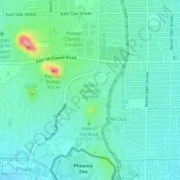
Nombre: Mapa topográfico Desert Botanical Garden, altitud, relieve.
Altitud media: 389 m
Altitud mínima: 362 m
Altitud máxima: 495 m
Gracias por apoyar a este sitio ❤️
Haz una donación
Haz una donación
Otros mapas topográficos
Haga clic en un mapa para ver su topografía, su altitud y su relieve.
Phoenix
United States > Arizona > Maricopa County > Phoenix
Phoenix is in the south-central portion of Arizona; about halfway between Tucson to the southeast and Flagstaff to the north, in the southwestern United States. By car, the city is approximately 150 miles (240 kilometers) north of the US–Mexico border at Sonoyta and 180 mi (290 km) north of the border at…
Altitud media: 368 m
Gracias por apoyar a este sitio ❤️
Haz una donación
Haz una donación