
Gracias por apoyar a este sitio ❤️
Haz una donación
Haz una donación
Mapa topográfico Anthem
Haga clic en el mapa para ver la altitud.
Gracias por apoyar a este sitio ❤️
Haz una donación
Haz una donación
Anthem
Anthem is built on 5,856 acres (9.2 sq mi) at the base of Daisy Mountain and Gavilan Peak. The community's elevation ranges from 1,760 feet to 2,428 feet, with an average elevation of 1,863 feet. Approximately 36 percent of the community is preserved as open space, including 291 acres of open hillside.
Gracias por apoyar a este sitio ❤️
Haz una donación
Haz una donación
Acerca de este mapa
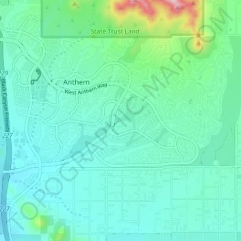
Nombre: Mapa topográfico Anthem, altitud, relieve.
Lugar: Anthem, Maricopa County, Arizona, United States (33.82719 -112.14685 33.87839 -112.08264)
Altitud media: 580 m
Altitud mínima: 521 m
Altitud máxima: 856 m
Gracias por apoyar a este sitio ❤️
Haz una donación
Haz una donación