
Haz una donación
Mapa topográfico Garrett Park
Haga clic en el mapa para ver la altitud.
Haz una donación
Acerca de este mapa
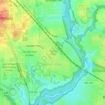
Nombre: Mapa topográfico Garrett Park, altitud, relieve.
Altitud media: 90 m
Altitud mínima: 65 m
Altitud máxima: 131 m
Haz una donación
Otros mapas topográficos
Haga clic en un mapa para ver su topografía, su altitud y su relieve.
Haz una donación
Haz una donación
Great Falls
United States > Maryland > Montgomery County > Potomac
The rocks of the falls date to the late Precambrian and are about 750 million years old. The rocks are a resistant metamorphized schist, gneisses, metagraywackes, and metaconglomerates. The Falls formed the last time sea level dropped, during the Last Glacial Period about 35,000 years ago, causing the Potomac…
Altitud media: 73 m
Haz una donación
Seneca
United States > Maryland > Montgomery County > Darnestown
Seneca is located close to the intersection of River Road (Maryland Route 190), Seneca Road (Maryland route 112), and Rileys Lock Road, east of Great Seneca Creek and north of the Potomac River. The C&O Canal runs along the river, and Riley's Lock is the closest canal lock. The southern portion of Seneca Creek…
Altitud media: 82 m
Haz una donación
Haz una donación
Haz una donación
Haz una donación
Brookeville Heights
United States > Maryland > Montgomery County > Brookeville Heights
Altitud media: 139 m
Garrett Park Estates
United States > Maryland > Montgomery County > Garrett Park Estates
Altitud media: 97 m
Haz una donación