
Haz una donación
Mapa topográfico Magothy River
Haga clic en el mapa para ver la altitud.
Haz una donación
Magothy River
Almost all of the creeks and tidal coves on the Magothy are named, partly as the result of a project started in 2001 by the Magothy River Association. They are shown on a map produced as part of that project, and the major ones are shown on the USGS topographic map.
Haz una donación
Acerca de este mapa
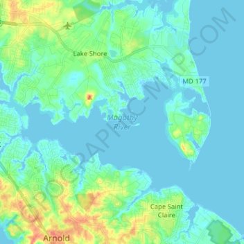
Nombre: Mapa topográfico Magothy River, altitud, relieve.
Altitud media: 9 m
Altitud mínima: -3 m
Altitud máxima: 46 m
Haz una donación
Otros mapas topográficos
Haga clic en un mapa para ver su topografía, su altitud y su relieve.
Lower Magothy Beach
United States > Maryland > Anne Arundel County > Severna Park > Lower Magothy Beach
Altitud media: 9 m
Windrush Farm
United States > Maryland > Anne Arundel County > Severna Park > Windrush Farm
Altitud media: 10 m
Haz una donación
Severndale
United States > Maryland > Anne Arundel County > Severna Park > Severndale
Altitud media: 18 m
Linstead-on-the-Severn
United States > Maryland > Anne Arundel County > Severna Park
Altitud media: 11 m