
Haz una donación
Mapa topográfico Attica
Haga clic en el mapa para ver la altitud.
Haz una donación
Acerca de este mapa
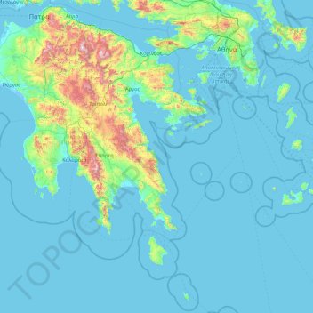
Nombre: Mapa topográfico Attica, altitud, relieve.
Lugar: Attica, Greece (35.72143 22.76581 38.37816 24.14635)
Altitud media: 155 m
Altitud mínima: -5 m
Altitud máxima: 2.327 m
Haz una donación
Otros mapas topográficos
Haga clic en un mapa para ver su topografía, su altitud y su relieve.
Olympus
Greece > Attica > Regional Unit of North Athens > Municipal Unit of Psychiko
Altitud media: 204 m
Haz una donación
Astypalaia
Greece > Attica > Regional Unit of East Attica > Anavissos Municipal Unit
Altitud media: 10 m
Agios Nektarios
Greece > Attica > Regional Unit of West Attica > Municipal Unit of Vilia
Altitud media: 695 m
Haz una donación
Palaio Faliro
Greece > Attica > Regional Unit of South Athens
Phaleron was an important place in antiquity, then as now one of the demes of Athens; however, a precise definition of its Classical topography is lacking, although the location of the deme is well established. Pausanias records that it was on the coast, equidistant from Athens and Cape Kolias (i.e., Ayios…
Altitud media: 27 m
Methana
Greece > Attica > Regional Unit of Islands > Municipal Unit of Methana
Since 1991, the peninsula has been investigated by the team of ETH Zürich geologically and cartographically. From this, a topographical map of the entire peninsula at a scale of 1:25,000 was made. An interactive 3D map was created and is on the World Wide Web. Also a rich photographic archive with about…
Altitud media: 123 m
Haz una donación
Ευαγγελίστριας
Greece > Attica > Regional Unit of Islands > Salamina Municipal Unit > Σατερλί
Altitud media: 23 m
Keratsini
Greece > Attica > Regional Unit of Piraeus > Municipal Unit of Keratsini
Altitud media: 73 m
Haz una donación
Christoupoli
Greece > Attica > Regional Unit of East Attica > Spata-Loutsa Municipal Unit
Altitud media: 122 m
Haz una donación
Ανάβυσσος
Greece > Attica > Regional Unit of East Attica > Anavissos Municipal Unit
Altitud media: 91 m
Haz una donación
Psatha
Greece > Attica > Regional Unit of West Attica > Municipal Unit of Vilia > Psatha
Altitud media: 79 m
Haz una donación