
Haz una donación
Mapa topográfico Lydia
Haga clic en el mapa para ver la altitud.
Haz una donación
Acerca de este mapa
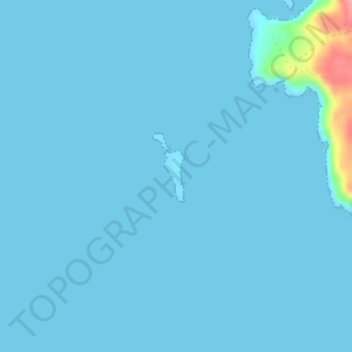
Nombre: Mapa topográfico Lydia, altitud, relieve.
Lugar: Lydia, Regional Unit of Islands, Attica, Greece (36.18999 22.89973 36.19397 22.90164)
Altitud media: 4 m
Altitud mínima: 0 m
Altitud máxima: 92 m
Haz una donación
Otros mapas topográficos
Haga clic en un mapa para ver su topografía, su altitud y su relieve.
Antikythera
Greece > Attica > Regional Unit of Islands > Municipal Unit of Antikythira
Altitud media: 30 m
Haz una donación
Poros
Greece > Attica > Regional Unit of Islands > Poros
The land area of the municipality (which includes the islands and part of the adjacent Peloponnese coast) is 49.582 square kilometres (19.144 sq mi). The landscape is very hilly and mountainous. The highest peak is the Vigla (358 m) in the west-central part. Following the island's topography and geology, small…
Altitud media: 31 m
Methana
Greece > Attica > Regional Unit of Islands > Municipal Unit of Methana
Since 1991, the peninsula has been investigated by the team of ETH Zürich geologically and cartographically. From this, a topographical map of the entire peninsula at a scale of 1:25,000 was made. An interactive 3D map was created and is on the World Wide Web. Also a rich photographic archive with about…
Altitud media: 123 m
Ευαγγελίστριας
Greece > Attica > Regional Unit of Islands > Salamina Municipal Unit > Σατερλί
Altitud media: 23 m
Haz una donación