
Haz una donación
Mapa topográfico Valley County
Haga clic en el mapa para ver la altitud.
Haz una donación
Acerca de este mapa
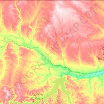
Nombre: Mapa topográfico Valley County, altitud, relieve.
Lugar: Valley County, Montana, United States (47.66036 -107.41489 49.00006 -105.80441)
Altitud media: 775 m
Altitud mínima: 601 m
Altitud máxima: 1.007 m
Haz una donación
Otros mapas topográficos
Haga clic en un mapa para ver su topografía, su altitud y su relieve.
Haz una donación
West Glacier
United States > Montana > Flathead County
The community, heavily dependent on tourism, has a small permanent population that expands significantly during the summer tourist season; most area businesses are likewise seasonal—including the 18-hole golf course—and are primarily geared towards travelers. The elevation is 3,169 feet (966 m).
Altitud media: 1.201 m
Haz una donación
Haz una donación
Haz una donación
Haz una donación
Haz una donación
Haz una donación
Kootenai River
United States > Montana > Lincoln County
Comparisons of various U.S. Geological Survey (USGS) topographic maps from the 20th century show many misinterpretations or alternative names being applied to the segment of the river within the United States. These include "Kootanie", "Kootenie", and "Kootienay". The Geographic Names Information System of the…
Altitud media: 864 m
Haz una donación
Yellowstone River
United States > Montana > Custer County
The mainstem of the Yellowstone River is more than 700 miles (1,100 km) long. At the headwaters, elevations exceed 12,800 feet (3,900 m) above sea level, descending to 1,850 feet (560 m) at the confluence with the Missouri River in far western North Dakota. The watershed spans 34,167 square miles (88,490 km2).…
Altitud media: 719 m
Bitterroot Range
United States > Montana > Ravalli County
The site of Brower's Spring is at about 8,800 feet (2,680 m) in elevation in the Centennials. The site is now commemorated by a rock cairn at the source of Hellroaring Creek, which flows into the Red Rock River and then into Clark canyon reservoir, where it joins the Beaverhead River and then the Big Hole…
Altitud media: 2.112 m
Haz una donación
Haz una donación
Mount Cleveland
United States > Montana > Glacier County
While not of great absolute elevation (the mountain is more than 2,300 ft (700 m) lower than Granite Peak, the highest peak in Montana), Mount Cleveland is notable for its large, steep rise above local terrain. For example, its west flank rises over 5,500 ft (1,700 m) in less than 2 mi (3.2 km); the northwest…
Altitud media: 2.339 m
Haz una donación
Haz una donación
Haz una donación
Haz una donación
Haz una donación
Haz una donación
Fort Peck Indian Reservation Historical Marker
United States > Montana > Roosevelt County > Poplar
Altitud media: 600 m
Haz una donación
Haz una donación
Haz una donación
Garnet
United States > Montana > Granite County
In First Chance Gulch in western Montana, the town is located 11 miles up the Garnet Range Road, in mountains and forest. The town is at approximately 6,000 feet (1,800 m) elevation. The nearest city is Missoula, approximately 20 miles (32 km) to the west. The closest city to the east is Butte, about 100 miles…
Altitud media: 1.758 m
Haz una donación
Haz una donación
Haz una donación
Haz una donación
Haz una donación
Gallatin Gateway
United States > Montana > Gallatin County
Gallatin Gateway is a census-designated place (CDP) in Gallatin County, Montana, United States. As of the 2020 census, Gallatin Gateway had a population of 967. Elevation is 4,953 ft (1,510 m).
Altitud media: 1.519 m
Haz una donación