
Haz una donación
Mapa topográfico Clancy
Haga clic en el mapa para ver la altitud.
Haz una donación
Acerca de este mapa
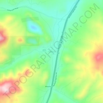
Nombre: Mapa topográfico Clancy, altitud, relieve.
Lugar: Clancy, Jefferson County, Montana, 59638, United States (46.44490 -112.00666 46.48490 -111.96666)
Altitud media: 1.370 m
Altitud mínima: 1.231 m
Altitud máxima: 1.605 m
Haz una donación
Otros mapas topográficos
Haga clic en un mapa para ver su topografía, su altitud y su relieve.
Boulder
United States > Montana > Jefferson County
Boulder lies at an elevation of 4,990 feet (1,521 m) above sea level along Interstate 15 at its intersection with Montana Highway 69, approximately 35 miles (56 km) north of Butte, and 27 miles (43 km) south of Helena. The town is on the north bank of the Boulder River, a tributary of the Jefferson River.…
Altitud media: 1.511 m
Basin
United States > Montana > Jefferson County
Basin, in Jefferson County, is part of the Helena Micropolitan Statistical Area. It lies at an elevation of 5,364 feet (1,635 m) above sea level along Interstate 15 about 30 miles (48 km) by road north of Butte and 38 miles (61 km) south of Helena in a narrow canyon. The community is largely surrounded by the…
Altitud media: 1.892 m