
Gracias por apoyar a este sitio ❤️
Haz una donación
Haz una donación
Mapa topográfico Kountz Dam
Haga clic en el mapa para ver la altitud.
Gracias por apoyar a este sitio ❤️
Haz una donación
Haz una donación
Acerca de este mapa
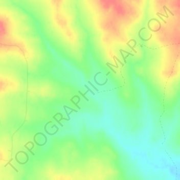
Nombre: Mapa topográfico Kountz Dam, altitud, relieve.
Lugar: Kountz Dam, Custer County, Montana, United States (46.83829 -105.88062 46.83839 -105.88052)
Altitud media: 902 m
Altitud mínima: 873 m
Altitud máxima: 936 m
Gracias por apoyar a este sitio ❤️
Haz una donación
Haz una donación
Otros mapas topográficos
Haga clic en un mapa para ver su topografía, su altitud y su relieve.
Yellowstone River
United States > Montana > Custer County
The mainstem of the Yellowstone River is more than 700 miles (1,100 km) long. At the headwaters, elevations exceed 12,800 feet (3,900 m) above sea level, descending to 1,850 feet (560 m) at the confluence with the Missouri River in far western North Dakota. The watershed spans 34,167 square miles (88,490 km2).…
Altitud media: 719 m