
Haz una donación
Mapa topográfico Kangding
Haga clic en el mapa para ver la altitud.
Haz una donación
Kangding
Kangding has a monsoon-influenced climate, lying in the transition between a humid continental (Dwb) and a subtropical highland climate (Cwb) on the Köppen system. Despite the elevation of 2,560 metres (8,400 ft), the diurnal temperature variation averages at most 10.6 °C (19.1 °F) in any month. From April to September, rain is a very common occurrence, with around two-thirds of the days receiving some rainfall; in addition, 77% of the annual precipitation is delivered from May to September. Monthly daily average temperatures range from −1.9 °C (28.6 °F) in January to 15.7 °C (60.3 °F) in July; the annual mean is 7.29 °C (45.1 °F). Over the course of the year, the frost-free period lasts 177 days and there are 1,738 hours of sunshine. The highest temperature ever recorded in Kangding was a high temperature record of 30.1 °C (86.2 °F) measured on March 30, 2007.
Haz una donación
Acerca de este mapa
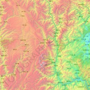
Nombre: Mapa topográfico Kangding, altitud, relieve.
Lugar: Kangding, Kardze, Sichuan, 626000, China (29.13699 101.00520 30.76818 102.49243)
Altitud media: 3.331 m
Altitud mínima: 658 m
Altitud máxima: 7.423 m
Haz una donación
Otros mapas topográficos
Haga clic en un mapa para ver su topografía, su altitud y su relieve.
Jiuzhaigou
China > Sichuan > Jiuzhaigou County
The county consists of nine villages in a valley in Sichuan Province. The main ethnic group in the county is Han, with the second being Tibetan. The county seat has an altitude of about 1,400 m (4,600 ft).[1] It has a total area of 2,041 square miles (5,286 km2).[2] As of 2015, the county's total population…
Altitud media: 2.520 m
Haz una donación
Garzê Tibetan Autonomous Prefecture
China > Sichuan > Garzê Tibetan Autonomous Prefecture
Altitud media: 3.899 m
Haz una donación
Qingcheng Mountain
"Located at the peak of Mount Qingcheng with an altitude over 1,500 m, Shangqing Palace marks the end of the touring route of Mount Qingcheng. Buildings such as Laojun Hall, Sanqing Hall, Wenwu Hall, and Tao Te Ching Preaching Hall in the Taoist temple of Shangqing Palace with several cultural relics, were…
Altitud media: 972 m
Haz una donación
Mount Emei
China > Sichuan > Emeishan City > Emeishan
The flora of Mount Emei varies with elevation, from subtropical evergreen forests at lower elevations to subalpine shrubland around the summit. The mountain is notable for both its species richness and abundance of endemic plants.
Altitud media: 2.434 m
Haz una donación
Mount Gongga
Mount Gongga (simplified Chinese: 贡嘎山; traditional Chinese: 貢嘎山; pinyin: Gònggá Shān), also known as Minya Konka (Khams Tibetan: མི་ཉག་གངས་དཀར་རི་བོ་, Khams Tibetan pinyin: Mi'nyâg Gong'ga Riwo) and colloquially as "The King of Sichuan Mountains", is the…
Altitud media: 6.496 m
Haz una donación
Haz una donación
Haz una donación
Haz una donación
Haz una donación
Haz una donación
Haz una donación
Haz una donación
Haz una donación
Haz una donación
Haz una donación
Haz una donación
Haz una donación
Haz una donación
Haz una donación
Haz una donación
Haz una donación
Haz una donación
Tagong
A gompa is where the Tagong Monastery is located. The gompa is one of the most important in the in Tibetan Pel Lhagong. The Tagong Monastery was established with reference to a nearby sacred mountain, Mt. Yala or Zhara Lhaste, which is 5,820 metres (19,090 ft) in elevation.
Altitud media: 3.874 m
Large High Altitude Air Shower Observatory
China > Sichuan > Daocheng County
The Large High Altitude Air Shower Observatory (LHAASO) is a gamma-ray and cosmic-ray observatory in Daocheng, in the Garzê Tibetan Autonomous Prefecture in Sichuan, China. It is designed to observe air showers triggered by gamma rays and cosmic rays. The observatory is at an altitude of 4,410 metres (14,470…
Altitud media: 4.421 m
Haz una donación
Haz una donación
Haz una donación