
Haz una donación
Mapa topográfico Qingcheng Mountain
Haga clic en el mapa para ver la altitud.
Haz una donación
Qingcheng Mountain
"Located at the peak of Mount Qingcheng with an altitude over 1,500 m, Shangqing Palace marks the end of the touring route of Mount Qingcheng. Buildings such as Laojun Hall, Sanqing Hall, Wenwu Hall, and Tao Te Ching Preaching Hall in the Taoist temple of Shangqing Palace with several cultural relics, were originally built in the Jin Dynasty."
Haz una donación
Acerca de este mapa
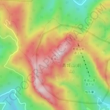
Nombre: Mapa topográfico Qingcheng Mountain, altitud, relieve.
Lugar: Qingcheng Mountain, Chengdu, Sichuan, 611844, China (30.91045 103.55773 30.91055 103.55783)
Altitud media: 972 m
Altitud mínima: 718 m
Altitud máxima: 1.222 m
Haz una donación
Otros mapas topográficos
Haga clic en un mapa para ver su topografía, su altitud y su relieve.
Wuhou District
The terrain of Wuhou District is flat, sloping from northwest to southeast, with an average altitude of 502.5 meters. The plains within the territory are composed of flood plains, alluvial fans, fan plains and other plains. The geological structure of the entire region is mainly Quaternary loose accumulations.
Altitud media: 492 m
Haz una donación