
Haz una donación
Mapa topográfico Monarch Mountain
Haga clic en el mapa para ver la altitud.
Haz una donación
Acerca de este mapa
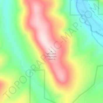
Nombre: Mapa topográfico Monarch Mountain, altitud, relieve.
Altitud media: 1.608 m
Altitud mínima: 1.423 m
Altitud máxima: 1.839 m
Haz una donación
Otros mapas topográficos
Haga clic en un mapa para ver su topografía, su altitud y su relieve.
Billings
United States > Montana > Yellowstone County
Two-thirds of the city is in the Yellowstone Valley and the South Hills area and one-third in the Heights-Lockwood area. The city is divided by the Rims, long cliffs, also called the Rimrocks. The Rims run to the north and east of the downtown core, separating it from the Heights to the north and Lockwood to…
Altitud media: 1.023 m
Glacier National Park
One of the most dramatic evidences of this overthrust is visible in the form of Chief Mountain, an isolated peak on the edge of the eastern boundary of the park rising 2,500 feet (800 m) above the Great Plains. There are six mountains in the park over 10,000 feet (3,000 m) in elevation, with Mount Cleveland at…
Altitud media: 1.594 m
Haz una donación
Kalispell
United States > Montana > Flathead County
Kalispell is located at 48°11′52″N 114°18′58″W / 48.19778°N 114.31611°W / 48.19778; -114.31611 (48.197801, −114.316068), at an elevation of 2,956 feet (901 m).
Altitud media: 934 m
Helena
United States > Montana > Lewis and Clark County
Helena is located at 46°35′45″N 112°1′37″W / 46.59583°N 112.02694°W / 46.59583; -112.02694 (46.595805, −112.027031), at an altitude of 4,058 feet (1,237 m).
Altitud media: 1.301 m
Big Sky
United States > Montana > Gallatin County
Big Sky is characterized by its dramatic and diverse topography, which forms part of the northern Rocky Mountains. The area features an elevation that ranges from around 5,500 feet in the valleys to more than 11,000 feet at its peaks, including the notable Lone Peak. This mountainous terrain is interspersed…
Altitud media: 2.435 m
Wisdom
United States > Montana > Beaverhead County > Wisdom
Wisdom is located at 45°36′58″N 113°26′59″W / 45.61611°N 113.44972°W / 45.61611; -113.44972 (45.616120, -113.449742). According to the United States Census Bureau, the CDP has a total area of 0.99 square miles (2.56 km2), of which 0.98 square miles (2.54 km2) is land and 0.0077 square…
Altitud media: 1.848 m
Haz una donación
Missoula
United States > Montana > Missoula County
Missoula is located at the western edge of Montana, approximately 45 miles (70 km) from the Idaho border. The city is at an elevation of 3,209 feet (978 m) above sea level, with nearby Mount Sentinel and Mount Jumbo steeply rising to 5,158 feet (1,572 m) and 4,768 feet (1,453 m), respectively. According to the…
Altitud media: 1.173 m
Haz una donación
Haz una donación
Haz una donación
Haz una donación
Chouteau County
The land is mostly rolling prairie, hence the high density of wheat farming. However, there is notable topography, namely some of Montana's forested island ranges. The Bear Paw Mountains rise in the northeast and the Little Rockies and the Highwood Ranges are in the southeast. Major rivers include the Teton…
Altitud media: 1.026 m
Haz una donación
Haz una donación
Haz una donación
Haz una donación
Haz una donación
Haz una donación
Haz una donación
Petroleum County
The county's eastern boundary is formed by the Musselshell River. According to the United States Census Bureau, the county has a total area of 1,674 square miles (4,340 km2), 1,655 square miles (4,290 km2) land and 19 square miles (49 km2) (1.1%) water. Its average elevation is 2,250–4,000 feet (690–1,220…
Altitud media: 916 m
Haz una donación
Red Lodge
United States > Montana > Carbon County
Red Lodge experiences a continental climate (Köppen Dfb) with cold, somewhat dry winters and warm, wetter summers. Summers are cooler than in areas of Montana further north, due to the high elevation. Winters however, are milder than areas further to the east due to the chinook wind influence, as with most of…
Altitud media: 1.720 m
Libby
United States > Montana > Lincoln County
According to the United States Census Bureau, the city has an area of 1.95 square miles (5.05 km2), of which 1.91 square miles (4.95 km2) is land and 0.04 square miles (0.10 km2) is water. Libby is in the Kootenai National Forest, between the Cabinet Mountains to the south and the Purcell Mountains to the…
Altitud media: 676 m
Haz una donación
Dillon
United States > Montana > Beaverhead County
Dillon is located at 45°12′57″N 112°38′3″W / 45.21583°N 112.63417°W / 45.21583; -112.63417 (45.215735, -112.634055), approximately 40 miles (64 km) east of the Continental Divide. It lies at an elevation of 5,102 feet (1,555 m).
Altitud media: 1.562 m
Livingston
United States > Montana > Park County
Livingston is located at 45°39′32″N 110°33′49″W / 45.65889°N 110.56361°W / 45.65889; -110.56361 (45.658840, -110.563718), at an elevation of 4,501 feet (1372 m).
Altitud media: 1.421 m
Haz una donación
Haz una donación
Bozeman
United States > Montana > Gallatin County
Bozeman is located at an elevation of 4,820 feet (1,470 m). The Bridger Mountains are to the north-northeast, the Tobacco Root Mountains to the west-southwest, the Big Belt Mountains and Horseshoe Hills to the northwest, the Hyalite Peaks of the northern Gallatin Range to the south and the Spanish Peaks of the…
Altitud media: 1.495 m
Haz una donación
Paradise
United States > Montana > Sanders County > Paradise
Paradise is located at 47°23′17″N 114°48′3″W / 47.38806°N 114.80083°W / 47.38806; -114.80083 (47.388097, -114.800723), elevation 2,250 feet (690 m). It is at the confluence of the Flathead River and Clark Fork River. Nearby Patrick's Knob reaches 6,775 feet (2,065 m).
Altitud media: 881 m
Butte
United States > Montana > Silver Bow County
Butte's South district, situated at a lower elevation below the hillside that comprises northern Butte, has historically been home to working-class neighborhoods. Gold mines originally populated south Butte before it was platted for the Union Pacific Railroad in 1881.
Altitud media: 1.909 m
Haz una donación
Haz una donación
Haz una donación
Bozeman
United States > Montana > Gallatin County
Bozeman is located at an elevation of 4,820 feet (1,470 m). The Bridger Mountains are to the north-northeast, the Tobacco Root Mountains to the west-southwest, the Big Belt Mountains and Horseshoe Hills to the northwest, the Hyalite Peaks of the northern Gallatin Range to the south and the Spanish Peaks of the…
Altitud media: 1.495 m
Haz una donación
Haz una donación
Haz una donación
Glasgow
United States > Montana > Valley County
According to the United States Census Bureau, the city has a total area of 1.43 square miles (3.7 km2), all land. The town has an elevation of 2,093 feet (638 m). It is nestled in the Milk River Valley with the river itself meandering along to south.
Altitud media: 654 m
Thompson Falls
United States > Montana > Sanders County
Thompson Falls is located at 47°35′48″N 115°20′37″W / 47.59667°N 115.34361°W / 47.59667; -115.34361 (47.596587, -115.343730) in the Clark Fork Valley at an elevation of 2,419 feet (737 m).
Altitud media: 782 m
Haz una donación