
Gracias por apoyar a este sitio ❤️
Haz una donación
Haz una donación
Mapa topográfico Niu Subdistrict
Haga clic en el mapa para ver la altitud.
Gracias por apoyar a este sitio ❤️
Haz una donación
Haz una donación
Acerca de este mapa
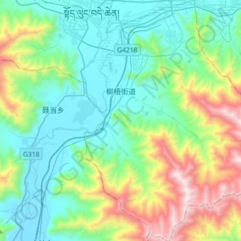
Nombre: Mapa topográfico Niu Subdistrict, altitud, relieve.
Lugar: Niu Subdistrict, Doilungdêqên District, Lhasa, Tibet, China (29.43444 90.99403 29.64766 91.17416)
Altitud media: 4.083 m
Altitud mínima: 3.600 m
Altitud máxima: 5.509 m
Gracias por apoyar a este sitio ❤️
Haz una donación
Haz una donación
Otros mapas topográficos
Haga clic en un mapa para ver su topografía, su altitud y su relieve.
Yangbajain
The Yangbajain hot springs field is at an elevation of 4,290 to 4,500 metres (14,070 to 14,760 ft) which makes it the highest elevation set of hot springs in China, and possibly the world. The highest temperature inside the drilling hole is 125.5°C.
Altitud media: 4.448 m