
Haz una donación
Mapa topográfico Yangbajain
Haga clic en el mapa para ver la altitud.
Haz una donación
Yangbajain
The Yangbajain hot springs field is at an elevation of 4,290 to 4,500 metres (14,070 to 14,760 ft) which makes it the highest elevation set of hot springs in China, and possibly the world. The highest temperature inside the drilling hole is 125.5°C.
Haz una donación
Acerca de este mapa
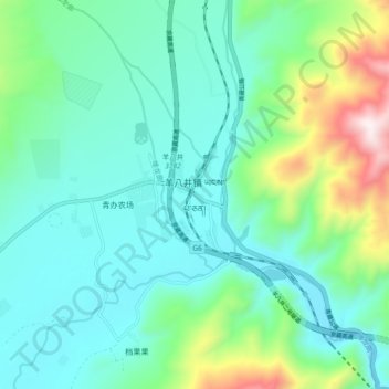
Nombre: Mapa topográfico Yangbajain, altitud, relieve.
Lugar: Yangbajain, Lhasa, Tibet, China (30.05796 90.49635 30.13796 90.57635)
Altitud media: 4.448 m
Altitud mínima: 4.241 m
Altitud máxima: 5.177 m
Haz una donación
Otros mapas topográficos
Haga clic en un mapa para ver su topografía, su altitud y su relieve.
Qüxü County
In the Tibetan language, the name means "water ditch." Qüxü County has a total area of 1,680 square kilometres (650 sq mi), with an average elevation of 3,650 metres (11,980 ft). The county is in the Yarlung Tsangpo valley, and is mostly relatively flat, but rises to the Nyainqêntanglha Mountains in the…
Altitud media: 4.514 m
Lhünzhub County
Lhünzhub County is situated in central Tibet, approximately 65 km (40 mi) northeast of Lhasa. The county encompasses the Pengbo River Valley and the upper reaches of the Lhasa River, covering an area of 4,512 km2 (1,742 sq mi). The region is geologically diverse, with an average elevation of 4,000 metres…
Altitud media: 4.634 m
Haz una donación