
Haz una donación
Mapa topográfico Joshua Tree National Park
Haga clic en el mapa para ver la altitud.
Haz una donación
Joshua Tree National Park
Joshua Tree National Park is an American national park in southeastern California, east of San Bernardino and Los Angeles and north of Palm Springs. It is named after the Joshua trees (Yucca brevifolia) native to the Mojave Desert. Originally declared a national monument in 1936, Joshua Tree was redesignated as a national park in 1994 when the U.S. Congress passed the California Desert Protection Act. Encompassing a total of 795,156 acres (1,242.4 sq mi; 3,217.9 km2) – slightly larger than the state of Rhode Island – the park includes 429,690 acres (671.4 sq mi; 1,738.9 km2) of designated wilderness. Straddling San Bernardino and Riverside Counties, the park includes parts of two deserts, each an ecosystem whose characteristics are determined primarily by elevation: the higher Mojave Desert and the lower Colorado Desert. The Little San Bernardino Mountains traverse the southwest edge of the park.
Haz una donación
Acerca de este mapa
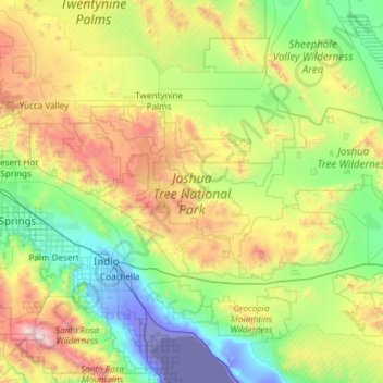
Nombre: Mapa topográfico Joshua Tree National Park, altitud, relieve.
Lugar: Joshua Tree National Park, California, United States (33.67019 -116.45803 34.12934 -115.26219)
Altitud media: 639 m
Altitud mínima: -71 m
Altitud máxima: 2.612 m
Haz una donación
Otros mapas topográficos
Haga clic en un mapa para ver su topografía, su altitud y su relieve.
San Francisco Bay Area
United States > California > San Francisco
The San Francisco Bay Area is characterized by a diverse and dynamic topography shaped by geological processes over millions of years. This region features a combination of coastal plains, steep hills, and rugged mountains, all influenced by the tectonic activity associated with the nearby San Andreas Fault…
Altitud media: 113 m
Ramona
United States > California > San Diego County
In January 2006, Ramona Valley was designated the country's 162nd American Viticultural Area (AVA) by the Alcohol and Tobacco Tax and Trade Bureau, which recognized the area for its distinctive microclimate, elevation, and soil attributes.
Altitud media: 469 m
Haz una donación
San Fernando Valley
United States > California > Los Angeles County > Los Angeles
Altitud media: 496 m
El Dorado Hills
United States > California > El Dorado County > Cameron Park
El Dorado Hills (EDH), as defined by the 2010 census-designated place (CDP), is at the western border of El Dorado County, between the City of Folsom and the unincorporated community of Cameron Park. The northern limits of the CDP are Folsom Lake and the South Fork of the American River, where river rafters…
Altitud media: 254 m
Haz una donación
Cajon Pass
United States > California > San Bernardino County
Cajon Pass (/kəˈhoʊn/; Spanish: Puerto del Cajón or Paso del Cajón) is a mountain pass between the San Bernardino Mountains to the east and the San Gabriel Mountains to the west in Southern California. Created by the movements of the San Andreas Fault, it has an elevation of 3,777 ft (1,151 m). Located in…
Altitud media: 1.169 m
Haz una donación
Pine Mountain Club
United States > California > Kern County
Pine Mountain Club has an area of 16.7 square miles (43.25 km2). It ranges from 4,901 to 6,400 feet (1,494 to 1,951 m) in elevation. The community sits in a deep valley of the San Emigdio Mountains, on the San Andreas fault. It is surrounded by Los Padres National Forest. The settlement lies between Apache…
Altitud media: 1.867 m
Haz una donación
Bodie
United States > California > Mono County
Bodie (/ˈboʊdiː/ BOH-dee) is a ghost town in the Bodie Hills east of the Sierra Nevada mountain range in Mono County, California, United States. It is about 75 miles (121 km) southeast of Lake Tahoe, and 12 mi (19 km) east-southeast of Bridgeport, at an elevation of 8,379 feet (2554 m). Bodie became a boom…
Altitud media: 2.627 m
Crescent City
United States > California > Del Norte County
The topography of the sea floor surrounding Crescent City has the effect of focusing tsunamis. According to researchers at Humboldt State University and the University of Southern California, the city experienced tsunami conditions 31 times between the years 1933 and 2008. Although many of these incidents were…
Altitud media: 31 m
Santa Cruz Mountains
United States > California > Santa Clara County
The Santa Cruz Mountains are a region of great biological diversity, encompassing cool, moist coastal ecosystems as well as warm, dry chaparral. Much of the area in the Santa Cruz mountains is considered temperate rainforest. In valleys and moist ocean-facing slopes some of the southernmost coast redwoods…
Altitud media: 230 m
Haz una donación
Lebec
United States > California > Kern County
According to the United States Census Bureau, Lebec has an area of 15.3 square miles (40 km2). The community, which is near Tejon Pass, lies at an elevation of 3,481 feet (1,061 m).
Altitud media: 1.162 m
Haz una donación
Crowley Lake
United States > California > Mono County
Crowley Lake is a census-designated place in Mono County, California. Crowley Lake sits at an elevation of 6,939 feet (2,115 m). The 2020 United States census reported Crowley Lake's population was 980.
Altitud media: 2.251 m
Haz una donación
Golden Gate Park
United States > California > San Francisco
In the 1860s, San Franciscans began to feel the need for a spacious public park similar to Central Park, which was then taking shape in New York City. Golden Gate Park was carved out of unpromising sand and shore dunes that were known as the Outside Lands, in an unincorporated area west of San Francisco's…
Altitud media: 71 m
Haz una donación
Haz una donación
Frazier Park
United States > California > Kern County
Frazier Park is an unincorporated community in Kern County, California. It is 5 miles (8 km) west of Lebec, at an elevation of 4,639 feet (1,414 m). It is one of the Mountain Communities of the Tejon Pass. The population was 2,691 in the 2010 census, up from 2,348 in 2000.
Altitud media: 1.533 m
Mount Baden-Powell
United States > California > Los Angeles County
At 9,407 feet (2,867 m) in elevation, Mount Baden-Powell is traditionally considered to be the 5th highest peak of the San Gabriel Range; however it is the second highest peak in the range with more than 1,000 feet (300 m) of prominence, and is the highest peak not part of the Mount San Antonio massif.
Altitud media: 2.429 m
Haz una donación
San Diego
United States > California > San Diego County > San Diego
The climate in San Diego, like most of Southern California, often varies significantly over short geographical distances, resulting in microclimates. In San Diego, this is mostly because of the city's topography (the Bay, and the numerous hills, mountains, and canyons). Frequently, particularly during the "May…
Altitud media: 57 m
McKinleyville
United States > California > Humboldt County
McKinleyville (formerly Minorsville) is a census-designated place (CDP) in Humboldt County, California McKinleyville is located 5.25 miles (8.4 km) north of Arcata, at an elevation of 141 feet (43 m). The population was 15,177 at the 2010 census, up from 13,599 at the time of the 2000 census.
Altitud media: 49 m
Haz una donación
Keene
United States > California > Kern County
Keene (formerly, Wells) is a census-designated place (CDP) in Kern County, California in the foothills of the Tehachapi Mountains at the southern extreme of the San Joaquin Valley. Keene is located 8.5 miles (14 km) northwest of Tehachapi, at an elevation of 2,602 feet (793 m). The population was 469 at the…
Altitud media: 892 m
Haz una donación
Haz una donación
Laguna Hills Park
United States > California > San Luis Obispo County > San Luis Obispo
Altitud media: 82 m
Haz una donación
Mount Shasta
United States > California > Siskiyou County
Mount Shasta (Shasta: Waka-nunee-Tuki-wuki; Karuk: Úytaahkoo) is a potentially active volcano at the southern end of the Cascade Range in Siskiyou County, California. At an elevation of 14,179 feet (4,321.8 meters), it is the second-highest peak in the Cascades and the fifth-highest in the state. Mount Shasta…
Altitud media: 3.717 m
Haz una donación
Diamond Springs
United States > California > El Dorado County
Diamond Springs (formerly, Diamond Spring and Diamond) is a census-designated place (CDP) in El Dorado County, California, United States. It is part of the Sacramento–Arden-Arcade–Roseville Metropolitan Statistical Area. The population was 11,037 at the 2010 census, up from 4,888 at the 2000 census. The…
Altitud media: 542 m
Haz una donación
Hilmar
United States > California > Merced County
Hilmar is an unincorporated community in Merced County, California, United States. It is located 4.25 miles (6.8 km) west-southwest of Delhi, spanning 3.9 sq mi (10 km2) and at an elevation of 92 ft (28 m) above sea level. For census purposes, Hilmar is aggregated with a nearby community into the Hilmar-Irwin…
Altitud media: 30 m
Haz una donación
Markleeville
United States > California > Alpine County
Markleeville hosts an annual bicycle ride called the Death Ride - Tour of the California Alps. The route goes over five passes for a total distance of 129 miles and over 15,000 feet of elevation gain. In 2010 3,500 riders participated and 2,417 completed the full course of 5 mountain passes.
Altitud media: 1.788 m
Haz una donación
Haz una donación
Contra Costa Centre
United States > California > Contra Costa County
Contra Costa Centre is an unincorporated community and census-designated place in Contra Costa County, California. Contra Costa Centre sits at an elevation of 92 feet (28 m). The 2010 United States census reported Contra Costa Centre's population was 5,364, while the 2020 census figure was 6,808. Contra Costa…
Altitud media: 36 m
Haz una donación
Dorrington
United States > California > Calaveras County
According to the United States Census Bureau, the CDP has a total area of 3.7 square miles (9.6 km2), 99.86% of it land. The elevation is 4,800 feet ASL.
Altitud media: 1.464 m
Haz una donación
Haz una donación
Oakhurst
United States > California > Madera County > Oakhurst
Oakhurst is located on the Fresno River 3 miles (5 km) south-southwest of Yosemite Forks, at an elevation of 2,274 feet (693 m). Its coordinates are 37°19′41″N 119°38′58″W / 37.32806°N 119.64944°W / 37.32806; -119.64944. It is located at the junction of state highways 41 and 49, at the…
Altitud media: 837 m
Haz una donación
Haz una donación
Shaver Lake
United States > California > Fresno County > Shaver Lake
Shaver Lake (formerly, Musick Creek and Musick Creek Heights) is a census-designated place (CDP) in Fresno County, California, United States. The population was 634 at the 2010 census, down from 705 at the 2000 census. Shaver Lake is on the southwest end of the lake of the same name, 10 miles (16 km) east of…
Altitud media: 1.437 m
Half Dome
United States > California > Mariposa County
The Half Dome Cable Route hike runs from the valley floor to the top of the dome in 8.2 mi (13 km) (via the Mist Trail), with 4,800 ft (1,460 m) of elevation gain. The length and difficulty of the trail used to keep it less crowded than other park trails, but in recent years the trail traffic has grown to as…
Altitud media: 1.887 m
Haz una donación