
Gracias por apoyar a este sitio ❤️
Haz una donación
Haz una donación
Mapa topográfico Oregon House
Haga clic en el mapa para ver la altitud.
Gracias por apoyar a este sitio ❤️
Haz una donación
Haz una donación
Acerca de este mapa
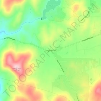
Nombre: Mapa topográfico Oregon House, altitud, relieve.
Altitud media: 486 m
Altitud mínima: 372 m
Altitud máxima: 629 m
Gracias por apoyar a este sitio ❤️
Haz una donación
Haz una donación
Otros mapas topográficos
Haga clic en un mapa para ver su topografía, su altitud y su relieve.
Beale AFB
United States > California > Yuba County
On 15 October 1964, the Department of Defense announced that Beale would be the home of the new, supersonic reconnaissance aircraft, the SR-71 Blackbird. The provisional 4200th Strategic Reconnaissance Wing (4200 SRW) activated on 1 January 1965 in preparation for the realignment, and the new wing received its…
Altitud media: 69 m
Gracias por apoyar a este sitio ❤️
Haz una donación
Haz una donación
Gracias por apoyar a este sitio ❤️
Haz una donación
Haz una donación