
Gracias por apoyar a este sitio ❤️
Haz una donación
Haz una donación
Mapa topográfico Arlington
Haga clic en el mapa para ver la altitud.
Gracias por apoyar a este sitio ❤️
Haz una donación
Haz una donación
Acerca de este mapa
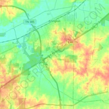
Nombre: Mapa topográfico Arlington, altitud, relieve.
Altitud media: 97 m
Altitud mínima: 73 m
Altitud máxima: 132 m
Gracias por apoyar a este sitio ❤️
Haz una donación
Haz una donación
Otros mapas topográficos
Haga clic en un mapa para ver su topografía, su altitud y su relieve.
Gracias por apoyar a este sitio ❤️
Haz una donación
Haz una donación
Gracias por apoyar a este sitio ❤️
Haz una donación
Haz una donación
Gracias por apoyar a este sitio ❤️
Haz una donación
Haz una donación
Cordova
United States > Tennessee > Shelby County > Memphis
Cordova is a community in Shelby County, Tennessee, United States. Cordova lies east of Memphis, north of Germantown, south of Bartlett, and northwest of Collierville at an elevation of 361 feet (110 meters).
Altitud media: 99 m
Gracias por apoyar a este sitio ❤️
Haz una donación
Haz una donación