
Gracias por apoyar a este sitio ❤️
Haz una donación
Haz una donación
Mapa topográfico Pisgah
Haga clic en el mapa para ver la altitud.
Gracias por apoyar a este sitio ❤️
Haz una donación
Haz una donación
Acerca de este mapa
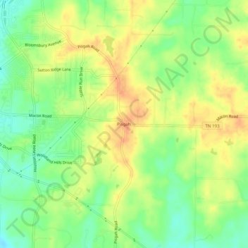
Nombre: Mapa topográfico Pisgah, altitud, relieve.
Altitud media: 108 m
Altitud mínima: 87 m
Altitud máxima: 126 m
Gracias por apoyar a este sitio ❤️
Haz una donación
Haz una donación
Otros mapas topográficos
Haga clic en un mapa para ver su topografía, su altitud y su relieve.
Memphis
United States > Tennessee > Shelby County
Memphis is characterized by a varied topography shaped by its location on the Chickasaw Bluffs overlooking the Mississippi River. The city itself sits at an elevation of about 300 feet, providing a scenic view of the river valley below. To the west, the landscape transitions into the Mississippi Alluvial…
Altitud media: 86 m
Gracias por apoyar a este sitio ❤️
Haz una donación
Haz una donación
Gracias por apoyar a este sitio ❤️
Haz una donación
Haz una donación
Gracias por apoyar a este sitio ❤️
Haz una donación
Haz una donación
Gracias por apoyar a este sitio ❤️
Haz una donación
Haz una donación
Gracias por apoyar a este sitio ❤️
Haz una donación
Haz una donación