
Haz una donación
Mapa topográfico Grand Bay
Haga clic en el mapa para ver la altitud.
Haz una donación
Acerca de este mapa
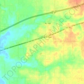
Nombre: Mapa topográfico Grand Bay, altitud, relieve.
Lugar: Grand Bay, Mobile County, Alabama, United States (30.45083 -88.38774 30.49360 -88.30958)
Altitud media: 22 m
Altitud mínima: 2 m
Altitud máxima: 44 m
Haz una donación
Otros mapas topográficos
Haga clic en un mapa para ver su topografía, su altitud y su relieve.
Mobile
United States > Alabama > Mobile County
According to the United States Census Bureau, the city has a total area of 180.1 square miles (466 km2), with 139.5 square miles (361 km2) of it being land, and 40.6 square miles (105.2 km2), or 22.5% of the total, being covered by water. The elevation in Mobile ranges from 10 feet (3 m) on Water Street in…
Altitud media: 16 m
Haz una donación
Semmes
United States > Alabama > Mobile County
Semmes is located in west-central Mobile County at 30°46′40″N 88°15′32″W / 30.77778°N 88.25889°W / 30.77778; -88.25889. The elevation is 244 feet (74 m) above sea level. It is 11 miles (18 km) west of Prichard and 15 miles (24 km) northwest of downtown Mobile. U.S. Route 98 (Moffett Road)…
Altitud media: 59 m
Haz una donación
Haz una donación
Haz una donación
Coden
United States > Alabama > Mobile County
Coden is located at 30°22′59″N 88°14′18″W / 30.38306°N 88.23833°W / 30.38306; -88.23833 and has an elevation of 7 feet (2 m).
Altitud media: 3 m
Chunchula
United States > Alabama > Mobile County
Chunchula is located in northern Mobile County at 30°55′19″N 88°12′02″W / 30.92185°N 88.20055°W / 30.92185; -88.20055 and has an elevation of 121 feet (37 m). U.S. Route 45 passes through the community, leading south 20 miles (32 km) to Mobile and north 12 miles (19 km) to Citronelle.
Altitud media: 39 m
Haz una donación
Mobile
United States > Alabama > Mobile County
According to the United States Census Bureau, the city has a total area of 180.1 square miles (466 km2), with 139.5 square miles (361 km2) of it being land, and 40.6 square miles (105.2 km2), or 22.5% of the total, being covered by water. The elevation in Mobile ranges from 10 feet (3 m) on Water Street in…
Altitud media: 16 m
Haz una donación
Haz una donación
Coden
United States > Alabama > Mobile County
Coden is located at 30°22′59″N 88°14′18″W / 30.38306°N 88.23833°W / 30.38306; -88.23833 and has an elevation of 7 feet (2 m).
Altitud media: 3 m
Mobile
United States > Alabama > Mobile County
According to the United States Census Bureau, the city has a total area of 180.07 square miles (466.4 km2), with 139.48 square miles (361.3 km2) of it being land, and 40.59 square miles (105.1 km2), or 22.5% of the total, being covered by water. The elevation in Mobile ranges from 10 feet (3 m) on Water Street…
Altitud media: 16 m
Haz una donación
Haz una donación
Haz una donación
Haz una donación
Semmes
United States > Alabama > Mobile County > Semmes
Semmes is located at 30.778N, -88.259W. Elevation is 256 feet. The Semmes area is bounded to the North by the Citronelle area, bounded to the East by the cities of Saraland and Prichard, bounded to the South by the city of Mobile, and finally bounded to the West by Big Creek Lake.
Altitud media: 68 m
Coronado Estates
United States > Alabama > Mobile County > Mobile > Coronado Estates
Altitud media: 37 m
Haz una donación