
Haz una donación
Mapa topográfico Dauphin Island
Haga clic en el mapa para ver la altitud.
Haz una donación
Acerca de este mapa
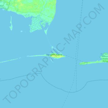
Nombre: Mapa topográfico Dauphin Island, altitud, relieve.
Lugar: Dauphin Island, Mobile County, Alabama, 36528, United States (30.19825 -88.39215 30.31289 -88.02678)
Altitud media: 0 m
Altitud mínima: -1 m
Altitud máxima: 12 m
Haz una donación
Otros mapas topográficos
Haga clic en un mapa para ver su topografía, su altitud y su relieve.
Haz una donación
Haz una donación
Coden
United States > Alabama > Mobile County
Coden is located at 30°22′59″N 88°14′18″W / 30.38306°N 88.23833°W / 30.38306; -88.23833 and has an elevation of 7 feet (2 m).
Altitud media: 3 m
Haz una donación
Haz una donación
Coden
United States > Alabama > Mobile County
Coden is located at 30°22′59″N 88°14′18″W / 30.38306°N 88.23833°W / 30.38306; -88.23833 and has an elevation of 7 feet (2 m).
Altitud media: 3 m
Haz una donación
Haz una donación
Semmes
United States > Alabama > Mobile County > Semmes
Semmes is located at 30.778N, -88.259W. Elevation is 256 feet. The Semmes area is bounded to the North by the Citronelle area, bounded to the East by the cities of Saraland and Prichard, bounded to the South by the city of Mobile, and finally bounded to the West by Big Creek Lake.
Altitud media: 68 m
Coronado Estates
United States > Alabama > Mobile County > Mobile > Coronado Estates
Altitud media: 37 m
Haz una donación