
Haz una donación
Mapa topográfico Asyut
Haga clic en el mapa para ver la altitud.
Haz una donación
Asyut
Köppen-Geiger climate classification system classifies its climate as hot desert (BWh). It is the driest city of Egypt. Luxor, Minya, Qena and Asyut have the widest difference of temperatures between days and nights of any city in Egypt, with almost 16 °C (29 °F) difference. The city of Asyut is sandwiched between two mountain ranges of about 600m height. There is also a lowering in elevation in mid Egypt, from the Mediterranean and the Red Sea. This gives the city and nearby towns and villages the similar properties of a continental climate, meaning that the city has harsh and chilly cold winter weather, and very hot but non-humid summers. During summer the temperature can exceed 42 °C (108 °F). Yet, in winter Asyut gets below 0 °C (32 °F) temperatures during the night and frost can easily form, while hail or snow are rare because of the low average of the city's precipitation and general low humidity.
Haz una donación
Acerca de este mapa
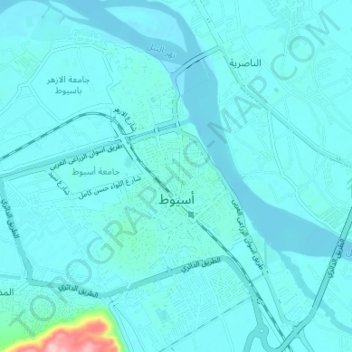
Nombre: Mapa topográfico Asyut, altitud, relieve.
Lugar: Asyut, Egypt (27.15725 31.14740 27.21658 31.21178)
Altitud media: 57 m
Altitud mínima: 43 m
Altitud máxima: 220 m
Haz una donación
Otros mapas topográficos
Haga clic en un mapa para ver su topografía, su altitud y su relieve.
Haz una donación