
Haz una donación
Mapa topográfico Kaifu
Haga clic en el mapa para ver la altitud.
Haz una donación
Acerca de este mapa
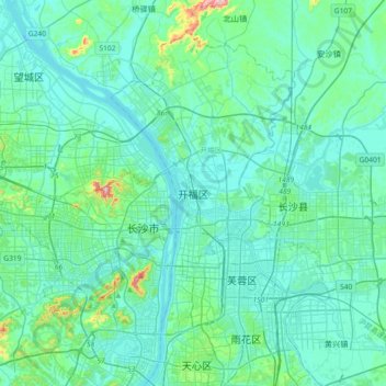
Nombre: Mapa topográfico Kaifu, altitud, relieve.
Lugar: Kaifu, Kaifu District, Changsha, Hunan, 410003, China (28.09931 112.82067 28.41931 113.14067)
Altitud media: 57 m
Altitud mínima: 18 m
Altitud máxima: 340 m
Haz una donación
Otros mapas topográficos
Haga clic en un mapa para ver su topografía, su altitud y su relieve.
Zhangjiajie Tianmen Mountain National Forest Park
China > Hunan > Yongding District
Altitud media: 781 m
Zhangjiajie Tianmen Mountain National Forest Park
China > Hunan > Yongding District
Altitud media: 781 m
Haz una donación
Haz una donación
Shaoshan
Shaoshan's topography is dominated by Mt. Shaofeng and the Shao and Shishi Rivers, with hills in the west giving rise to a mix of hills and plains in the east. The peak of Mount Shaofeng, 518.5 m above sea level, is the highest point whereas Liumuzhou, 48 m above sea level, is the lowest point of the whole…
Altitud media: 115 m
Haz una donación
Xiangxi
Xiangxi Tujia and Miao Autonomous Prefecture is located in a low-latitude zone and has a humid subtropical monsoon climate. It is characterized by the influence of the topography of the Wuling Mountains: the winter is relatively cold, the summer temperature is high and humid, the spring and summer are wet and…
Altitud media: 547 m
Haz una donación
Jishou
Jishou lies east of the Wuling Mountain range. About 80% of the city's terrain is low hills or low mountains. The highest elevation is 964.5 meters, at Liantaifeng (莲台峰; 蓮台峰, near the town of Aizhai (矮寨) and the lowest point is 142 meters, near the town of Hexi (simplified Chinese: 河溪镇;…
Altitud media: 447 m
Haz una donación
Haz una donación
Haz una donación
Haz una donación
Haz una donación
Guidong County
Guidong County belongs to the subtropical monsoon humid climate zone, no summer heat, no winter cold, warm and humid, four seasons. In spring, the southeast wind into the cold and warm air masses fronts in the territory of the confrontation hovering, insufficient light, cloudy temperature and rain. In summer,…
Altitud media: 887 m
Haz una donación
Haz una donación
Changde
The larger prefecture-level city of Changde is adjacent to Dongting Lake to the east, the city of Yiyang to the south, Wuling and Xuefeng Mountains to the west, and Hubei province to the north. Near the border with Hubei province in Shimen county is Huping Mountain (壶瓶山), the highest peaks in Hunan…
Altitud media: 171 m
Haz una donación
Haz una donación
Haz una donación