
Mapa topográfico Changde
Haga clic en el mapa para ver la altitud.
Changde
The larger prefecture-level city of Changde is adjacent to Dongting Lake to the east, the city of Yiyang to the south, Wuling and Xuefeng Mountains to the west, and Hubei province to the north. Near the border with Hubei province in Shimen county is Huping Mountain (壶瓶山), the highest peaks in Hunan province with an altitude of 2,099 metres (6,886 ft).
Acerca de este mapa
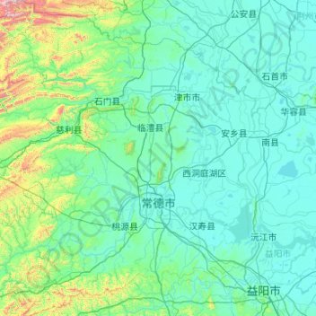
Nombre: Mapa topográfico Changde, altitud, relieve.
Lugar: Changde, Hunan, China (28.40850 110.48688 30.12843 112.30160)
Altitud media: 171 m
Altitud mínima: 20 m
Altitud máxima: 2.054 m
Otros mapas topográficos
Haga clic en un mapa para ver su topografía, su altitud y su relieve.
Zhangjiajie Tianmen Mountain National Forest Park
China > Hunan > Yongding District
Altitud media: 781 m
Zhangjiajie Tianmen Mountain National Forest Park
China > Hunan > Yongding District
Altitud media: 781 m
Ningxiang
China > Hunan > Ningxiang > Yutan Subdistrict
The highest natural elevation in Ningxiang County is 1071m at Wazizhai (瓦子寨).
Altitud media: 83 m
Xiangxi
China > Hunan > Jishou City > Zhenxi Subdistrict
Xiangxi Tujia and Miao Autonomous Prefecture is located in a low-latitude zone and has a humid subtropical monsoon climate. It is characterized by the influence of the topography of the Wuling Mountains: the winter is relatively cold, the summer temperature is high and humid, the spring and summer are wet and…
Altitud media: 542 m