
Haz una donación
Mapa topográfico Haldwani
Haga clic en el mapa para ver la altitud.
Haz una donación
Haldwani
Haldwani is located at 29°13′N 79°31′E / 29.22°N 79.52°E / 29.22; 79.52, in the Nainital district on the right bank of the Gaula River. Geologically, Haldwani is settled on a piedmont grade (called Bhabhar) where the mountain rivers go underground to re-emerge in the Indo-Gangetic plain. The Haldwani Bhabhar stretches horizontally, surrounded by the regions of Ramnagar and Tanakpur and lies between the Shivalik hills to the north and the Terai region of Rudrapur to the south. The average land elevation is 424 m (1,391 ft) above sea level. According to the Bureau of Indian Standards, Haldwani falls under seismic zone 4, in a scale of 2 to 5 (in order of increasing vulnerability to earthquakes).
Haz una donación
Acerca de este mapa
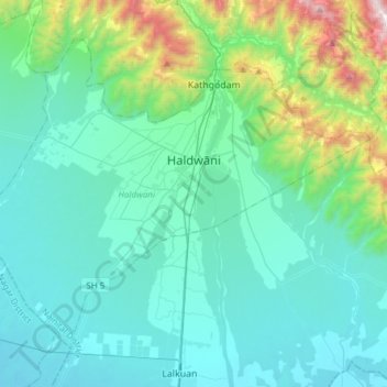
Nombre: Mapa topográfico Haldwani, altitud, relieve.
Lugar: Haldwani, Nainital, Uttarakhand, India (29.08355 79.36296 29.29770 79.66641)
Altitud media: 523 m
Altitud mínima: 228 m
Altitud máxima: 2.111 m
Haz una donación
Otros mapas topográficos
Haga clic en un mapa para ver su topografía, su altitud y su relieve.
Roorkee
India > Uttarakhand > Roorkee
Roorkee is located at 29°52′N 77°53′E / 29.87°N 77.88°E / 29.87; 77.88. It has an average elevation of 268 metres (879 ft).
Altitud media: 270 m
Haz una donación
Haz una donación
Haz una donación
Haz una donación
Haz una donación
Haz una donación
Gangolihāt
India > Uttarakhand > Gangolihat
Gangolihat is located at 29°29′N 80°03′E / 29.48°N 80.05°E / 29.48; 80.05. It has an average elevation of 1,760 metres (5,773 feet). It is 78 km from Pithoragarh. The main town is at a hill top. The region is surrounded by two rivers Saryu and Ramganga. Which meet at Ghat at the foothill of…
Altitud media: 1.532 m
Haz una donación
Haz una donación
Haz una donación
Haz una donación
Haz una donación
Haz una donación
Uttarkashi
India > Uttarakhand > Bhatwari
It is the district headquarters of Uttarkashi district. Uttarkashi is situated on the banks of river Bhagirathi at an altitude of 1158 m above sea level. Uttarkashi is generally known as a holy town close to Rishikesh. It is located in the state of Uttarakhand in India. Uttarkashi is home to a number of…
Altitud media: 1.619 m
Haz una donación
Haz una donación