
Haz una donación
Mapa topográfico Etah
Haga clic en el mapa para ver la altitud.
Haz una donación
Etah
Eta is located at 27.63 ° N 78.67 ° E. [4] It has an average elevation of 170 m (557 ft). The Eisen River flows behind the village Ghazipur Pahor. Etah is a district in the Aligarh division of Uttar Pradesh province, India. It is bounded by Kasganj in the north, Mainpuri and Firozabad in the south, Farrakhabad in the east and Aligarh, Hathras, Mathura and Agra districts in the west. Which come in Uttar Pradesh. The district does not have a border with any other state.
Haz una donación
Acerca de este mapa
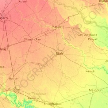
Nombre: Mapa topográfico Etah, altitud, relieve.
Lugar: Etah, Uttar Pradesh, India (27.32324 78.17557 27.78521 79.27717)
Altitud media: 168 m
Altitud mínima: 136 m
Altitud máxima: 201 m
Haz una donación
Otros mapas topográficos
Haga clic en un mapa para ver su topografía, su altitud y su relieve.
Haz una donación
Haz una donación
Haz una donación
Raebareli
India > Uttar Pradesh > Raebareli
The district forms a part of the Gangetic plain which is of recent origin according to geological chronology and reveal ordinary Gangetic alluvium. The district being a part of the alluvial plain conforms to the same geological sequence as the plain itself. The only mineral of importance is kankar. The…
Altitud media: 111 m
Govardhan
India > Uttar Pradesh > Mathura
Govardhana is located at 27°30′N 77°28′E / 27.5°N 77.47°E / 27.5; 77.47. It has an average elevation of 179 metres (587 feet). Govardhana has been made Tehsil in Mathura District by the Uttar Pradesh government.
Altitud media: 181 m
Haz una donación
Haz una donación
Sahaspur
India > Uttar Pradesh > Dhampur
Sahaspur is located at 29°07′16″N 78°37′16″E / 29.121°N 78.621°E / 29.121; 78.621. It has an average elevation of 199 metres (653 feet).
Altitud media: 217 m
Haz una donación