
Haz una donación
Mapa topográfico Faizabad
Haga clic en el mapa para ver la altitud.
Haz una donación
Acerca de este mapa
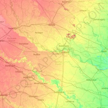
Nombre: Mapa topográfico Faizabad, altitud, relieve.
Lugar: Faizabad, Ayodhya District, Uttar Pradesh, 224188, India (26.05000 81.30000 27.45000 82.70000)
Altitud media: 101 m
Altitud mínima: 79 m
Altitud máxima: 126 m
Haz una donación
Otros mapas topográficos
Haga clic en un mapa para ver su topografía, su altitud y su relieve.
Haz una donación
Etah
Eta is located at 27.63 ° N 78.67 ° E. [4] It has an average elevation of 170 m (557 ft). The Eisen River flows behind the village Ghazipur Pahor. Etah is a district in the Aligarh division of Uttar Pradesh province, India. It is bounded by Kasganj in the north, Mainpuri and Firozabad in the south,…
Altitud media: 168 m
Jaunpur
The topography of the district is a flat plain undulating with shallow river valleys. The main permanently flowing rivers are the Gomti and the Sai. The rivers of Jaunpur flow from northwest to southeast and the land slopes in the same direction. Thus, there is a more elevated area in the northwest and a less…
Altitud media: 87 m
Haz una donación
Haz una donación
Haz una donación
Haz una donación
Haz una donación
Haz una donación
Pilibhit
The northeastern boundary of the reserve is the Sharda river (Nepali: Mahakali River) which defines the Indo-Nepal border, while the southwest boundary is marked by the River Sharda and the River Ghaghara. The reserve has a core zone area of 602.79 km2 (232.74 sq mi) and a buffer zone area of 127.45 km2 (49.21…
Altitud media: 177 m
Haz una donación
Haz una donación
Haz una donación