
Gracias por apoyar a este sitio ❤️
Haz una donación
Haz una donación
Mapa topográfico Gunlock
Haga clic en el mapa para ver la altitud.
Gracias por apoyar a este sitio ❤️
Haz una donación
Haz una donación
Gunlock
The community lies on the Santa Clara River, northwest of the Red Mountains along local roads, northwest of the city of St. George, the county seat of Washington County. Its elevation is 3,658 feet (1,115 m). Although Gunlock is unincorporated, it has a post office, with the ZIP code of 84733.
Gracias por apoyar a este sitio ❤️
Haz una donación
Haz una donación
Acerca de este mapa
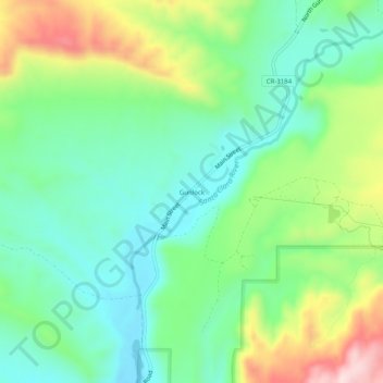
Nombre: Mapa topográfico Gunlock, altitud, relieve.
Lugar: Gunlock, Washington County, Utah, 84733, United States (37.26609 -113.78330 37.30609 -113.74330)
Altitud media: 1.210 m
Altitud mínima: 1.091 m
Altitud máxima: 1.457 m
Gracias por apoyar a este sitio ❤️
Haz una donación
Haz una donación
Otros mapas topográficos
Haga clic en un mapa para ver su topografía, su altitud y su relieve.
Gracias por apoyar a este sitio ❤️
Haz una donación
Haz una donación
Gracias por apoyar a este sitio ❤️
Haz una donación
Haz una donación