
Haz una donación
Mapa topográfico Deer Lodge
Haga clic en el mapa para ver la altitud.
Haz una donación
Acerca de este mapa
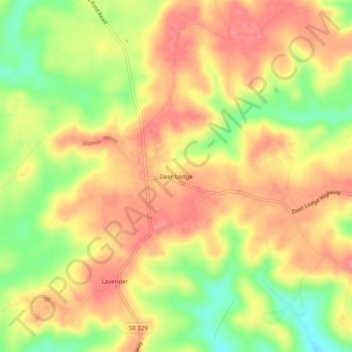
Nombre: Mapa topográfico Deer Lodge, altitud, relieve.
Altitud media: 466 m
Altitud mínima: 418 m
Altitud máxima: 498 m
Haz una donación
Otros mapas topográficos
Haga clic en un mapa para ver su topografía, su altitud y su relieve.
Frozen Head State Park
United States > Tennessee > Morgan County
Frozen Head State Park consists of approximately 24,000 acres (97 km2), all but 330 acres (1.3 km2) of which is classified as a state natural area. The terrain varies between 1,300 ft (400 m) to over 3,000 ft (910 m) with 14 peaks at or over 3,000 feet (910 m). Frozen Head, the park's namesake, is the highest…
Altitud media: 579 m
Haz una donación
Frozen Head State Park
United States > Tennessee > Morgan County
Frozen Head State Park consists of approximately 24,000 acres (97 km2), all but 330 acres (1.3 km2) of which is classified as a state natural area. The terrain varies between 1,300 ft (400 m) to over 3,000 ft (910 m) with 14 peaks at or over 3,000 feet (910 m). Frozen Head, the park's namesake, is the highest…
Altitud media: 579 m