
Haz una donación
Mapa topográfico Frozen Head State Park
Haga clic en el mapa para ver la altitud.
Haz una donación
Frozen Head State Park
Frozen Head State Park consists of approximately 24,000 acres (97 km2), all but 330 acres (1.3 km2) of which is classified as a state natural area. The terrain varies between 1,300 ft (400 m) to over 3,000 ft (910 m) with 14 peaks at or over 3,000 feet (910 m). Frozen Head, the park's namesake, is the highest peak at 3,324 feet (1,013 m). The mountain's name comes from its snow-capped appearance in colder months. The park's highest elevations allow for unobstructed views of East Tennessee's three main physiographic features: the Cumberland Plateau, the Tennessee Valley, and across the valley, the Great Smoky Mountains.
Haz una donación
Acerca de este mapa
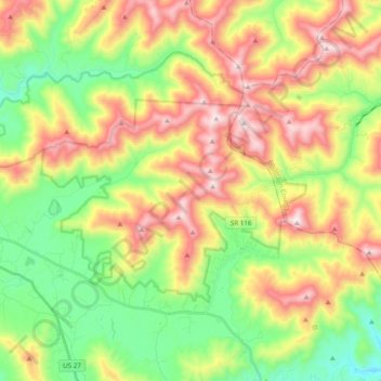
Nombre: Mapa topográfico Frozen Head State Park, altitud, relieve.
Altitud media: 579 m
Altitud mínima: 253 m
Altitud máxima: 1.011 m
Haz una donación
Otros mapas topográficos
Haga clic en un mapa para ver su topografía, su altitud y su relieve.