
Haz una donación
Mapa topográfico Arnold
Haga clic en el mapa para ver la altitud.
Haz una donación
Acerca de este mapa
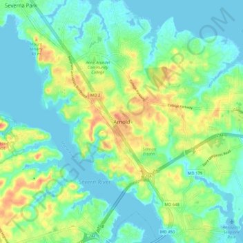
Nombre: Mapa topográfico Arnold, altitud, relieve.
Lugar: Arnold, Anne Arundel County, Maryland, 21012, United States (38.99208 -76.54254 39.07208 -76.46254)
Altitud media: 15 m
Altitud mínima: -3 m
Altitud máxima: 46 m
Haz una donación
Otros mapas topográficos
Haga clic en un mapa para ver su topografía, su altitud y su relieve.
Franklin Point State Park
United States > Maryland > Anne Arundel County > Columbia Beach
Altitud media: 1 m
Magothy River
United States > Maryland > Anne Arundel County > Severna Park
Almost all of the creeks and tidal coves on the Magothy are named, partly as the result of a project started in 2001 by the Magothy River Association. They are shown on a map produced as part of that project, and the major ones are shown on the USGS topographic map.
Altitud media: 9 m
Haz una donación
Cape St. Claire
United States > Maryland > Anne Arundel County > Cape Saint Claire
Altitud media: 12 m
Haz una donación
Forked Creek
United States > Maryland > Anne Arundel County > Arnold > Kimberly Woods Village
Altitud media: 22 m
Fort Smallwood Park
United States > Maryland > Anne Arundel County > Riviera Beach > Rockwood Beach
Altitud media: 2 m
Haz una donación