
Haz una donación
Mapa topográfico White Oak
Haga clic en el mapa para ver la altitud.
Haz una donación
Acerca de este mapa
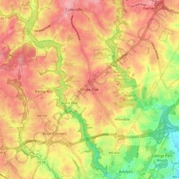
Nombre: Mapa topográfico White Oak, altitud, relieve.
Lugar: White Oak, Montgomery County, Maryland, 20904, United States (38.99983 -77.03303 39.07983 -76.95303)
Altitud media: 96 m
Altitud mínima: 27 m
Altitud máxima: 142 m
Haz una donación
Otros mapas topográficos
Haga clic en un mapa para ver su topografía, su altitud y su relieve.
Haz una donación
Haz una donación
Darnestown
United States > Maryland > Montgomery County
In the 2000 census, the Census Bureau created a new Census-designated place (CDP) called Darnestown. A Darnestown CDP was also used in the 2010 census. The Darnestown CDP has 16.39 square miles (42.4 km2) of land, which is smaller than the old Darnestown MCD. The CDP uses the Muddy Branch, Turkey Foot Road,…
Altitud media: 97 m
Haz una donación
Travilah
United States > Maryland > Montgomery County > Travilah
The United States Geological Survey lists six features in Montgomery County with Travilah in all or part of their name. The Travilah Census Designated Place has an ID of 2390400 and an elevation of 233 feet. It has a latitude of 390325N and a longitude of 0771445W—a location of 39°3′25″N…
Altitud media: 96 m
Haz una donación
Montgomery Village
United States > Maryland > Montgomery County > Montgomery Village
Altitud media: 132 m
Haz una donación