
Haz una donación
Mapa topográfico Ilam Province
Haga clic en el mapa para ver la altitud.
Haz una donación
Ilam Province
Contrary to the north, the south and southwestern part of the province is covered with low-lying plains with elevation varying between 50 and 300 m (160 and 980 ft) above sea level. Despite receiving little precipitation, large areas of these low lands, notably Dehloran, Musian and Dasht Abbas, are cultivated owing to a combination of factors such as rivers flowing from the mountains to the east, dams and irrigation networks.
Haz una donación
Acerca de este mapa
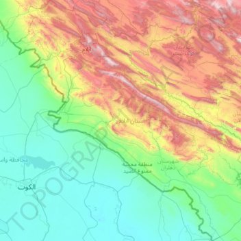
Nombre: Mapa topográfico Ilam Province, altitud, relieve.
Lugar: Ilam Province, Iran (32.04852 45.69252 34.03770 48.03564)
Altitud media: 630 m
Altitud mínima: 4 m
Altitud máxima: 2.803 m
Haz una donación
Otros mapas topográficos
Haga clic en un mapa para ver su topografía, su altitud y su relieve.
Haz una donación
Haz una donación
Haz una donación
Damavand
Iran > Mazandaran Province > Amol County > دهستان لاریجان سفلی
Mount Damavand (Persian: دماوند [dæmɒːˈvænd] English: /dɔːmoʊˈvænd/ Da-moh-VAND) is a dormant stratovolcano in Iran. It is the highest peak in Iran and Western Asia, the highest volcano in Asia, and the 3rd highest volcano in the Eastern Hemisphere (after Mount Kilimanjaro and Mount Elbrus), at…
Altitud media: 4.949 m
Haz una donación
Iranian plateau
Iran > South Khorasan Province > Tabas County > دهستان دیهوک
The northwestern Iranian plateau, where the Pontic and Taurus Mountains converge, is rugged country with higher elevations, a more severe climate, and greater precipitation than are found on the Anatolian plateau. The region is known as the Anti-Taurus, and the average elevation of its peaks exceeds 3,000 m…
Altitud media: 1.061 m
Haz una donación
Soltanabad-e Tanbali
Iran > Kurdistan Province > Bijar County > دهستان نجف آباد
Altitud media: 2.027 m
Damavand
Iran > Mazandaran Province > Amol County > دهستان لاریجان سفلی
Mount Damavand (Persian: دماوند [dæmɒːvænd] ) is a dormant stratovolcano and is the highest peak in Iran and Western Asia, the highest volcano in Asia, and the 3rd highest volcano in the Eastern Hemisphere (after Mount Kilimanjaro and Mount Elbrus), at an elevation of 5,609 metres (18,402 ft).…
Altitud media: 4.949 m
Haz una donación
Haz una donación
Haz una donación
Taftan
Iran > Sistan and Baluchestan Province > Mirjaveh County > دهستان تمین
Taftan is the highest mountain in southeast Iran. The topography is overall steep. Deep valleys with U and V shapes have developed on Taftan, and the volcano has a strongly eroded appearance. One of these valleys, Tamindan, may be the Damindan valley in the Avesta religious texts. One series of ignimbrites…
Altitud media: 3.525 m
Haz una donación
Pardisan Park
Iran > Sistan and Baluchestan Province > Zahedan County > Zahedan
Altitud media: 1.400 m
Haz una donación
Amlash
Iran > Gilan Province > Amlash County > دهستان املش شمالی
Amlash (Persian: املش) is a city in the Central District of Amlash County, Gilan province, in northwestern Iran, serving as the capital of both the county and the district. Amlash sits at an altitude of 13 metres (45 feet).
Altitud media: 66 m
Haz una donación
Haz una donación
Nehbandan
Iran > South Khorasan Province > Nehbandan County > دهستان نه
Nehbandan is located at an altitude of 1196 meters above sea level, and the heights of the north of this city reach 2500 meters above sea level. Nehbandan is located near the central desert of Iran. Precious stones in mines along with agriculture is another reason for the importance of Nehbandan. The people of…
Altitud media: 1.209 m
Haz una donación
سیوه کده سفلی
Iran > West Azerbaijan Province > Piranshahr County > دهستان لاهیجان شرقی
Altitud media: 1.978 m
Haz una donación
Haz una donación
Khalifan, Mahabad
Iran > West Azerbaijan Province > Mahabad County > دهستان کانی بازار
Altitud media: 1.558 m
Haz una donación
Suran
Iran > Sistan and Baluchestan Province > Sib and Suran County > دهستان سیب وسوران
Altitud media: 1.157 m
عزیزآباد پایین
Iran > Sistan and Baluchestan Province > Konarak County > دهستان تنگ
Altitud media: 9 m
Haz una donación
Haz una donación
East Azarbaijan
The highest point in East Azerbaijan is the volcanic peak of Sahand Mountain at 3,707 m (12,162 ft) of elevation, lying south of Tabriz, whereas the lower-lying areas are around Garmadooz (Ahar). The hills and mountains of the province are divided into three ranges: the Qara Daq Mountains, the Sahand and…
Altitud media: 1.249 m
Haz una donación
Natanz
Iran > Isfahan Province > Natanz County > دهستان کرکس
Natanz is located 120 km northeast of Isfahan and on the main north-south highway of Iran. Its altitude is 1666 meters above sea level. The distance between Tehran and Natanz is 326 km, and it takes about 4 hours by car. The Karkas mountain chain (Kuh-e Karkas) (meaning mountain of vultures), at an elevation…
Altitud media: 1.775 m
Kur Gaz-e Bala
Iran > South Khorasan Province > Birjand County > دهستان القورات
Altitud media: 1.861 m
Haz una donación
Haz una donación
Haz una donación
Haz una donación
Haz una donación
Haz una donación