
Haz una donación
Mapa topográfico Hashtgerd
Haga clic en el mapa para ver la altitud.
Haz una donación
Acerca de este mapa
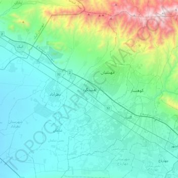
Nombre: Mapa topográfico Hashtgerd, altitud, relieve.
Altitud media: 1.516 m
Altitud mínima: 1.148 m
Altitud máxima: 3.270 m
Haz una donación
Otros mapas topográficos
Haga clic en un mapa para ver su topografía, su altitud y su relieve.
Mehestan
Iran > Alborz Province > Savojbolagh County
Mehestan is in the west of Alborz province at an altitude of 1,310 to 1,610 meters above sea level and between longitudes of 50 degrees 25 minutes and 50 degrees 55 minutes and latitudes of 35 degrees 45 minutes and 36 degrees 5 minutes. Hashtgerd plain generally has cold winters and hot and dry summers, but…
Altitud media: 1.425 m
Mehestan
Iran > Alborz Province > Savojbolagh County
The new city of Mehestan is geographically located in the west of Alborz province at an altitude of 1,310 to 1,610 meters above sea level and between longitudes of 50 degrees 25 minutes and 50 degrees 55 minutes and latitudes of 35 degrees 45 minutes and 36 degrees 5 minutes. Hashtgerd plain generally has cold…
Altitud media: 1.425 m