
Haz una donación
Mapa topográfico Trikala Regional Unit
Haga clic en el mapa para ver la altitud.
Haz una donación
Acerca de este mapa
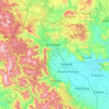
Nombre: Mapa topográfico Trikala Regional Unit, altitud, relieve.
Altitud media: 709 m
Altitud mínima: 83 m
Altitud máxima: 2.380 m
Haz una donación
Otros mapas topográficos
Haga clic en un mapa para ver su topografía, su altitud y su relieve.
Meteora
Greece > Thessaly > Trikala Regional Unit > Kastraki
The Monastery of Rousanou is believed to have been constructed, like many of the other monasteries, in the 14th century. The cathedral is believed to have been built in the 16th century and later decorated in 1540. The name Rousanou is believed to come from the first group of monks who settled on the rock from…
Altitud media: 429 m
Neo Perivoli
Greece > Thessaly > Larisa Regional Unit > Municipal Unit of Kileler
Altitud media: 146 m
Haz una donación
Περτούλι
Greece > Thessaly > Trikala Regional Unit
Pertouli is a small mountain village within the province of Trikala in Greece and is situated at an altitude of 1,150 metres on the central part of the Pindos mountain range.
Altitud media: 1.358 m
Περτούλι
Greece > Thessaly > Trikala Regional Unit
Pertouli is a small mountain village within the province of Trikala in Greece and is situated at an altitude of 1,150 metres on the central part of the Pindos mountain range.
Altitud media: 1.358 m
Haz una donación
Rapsani
Greece > Thessaly > Larisa Regional Unit > Municipal Unit of Kato Olympos
Rapsani is sited at an altitude of 600 meters. The location of Peneus river at the level of the station Rapsani is a scenic landscape. The town is close (5 km) from a station that bears the same name.
Altitud media: 501 m
Makrichori
Greece > Thessaly > Larisa Regional Unit > Municipal Unit of Makrichori
Altitud media: 139 m
Haz una donación
Makrichori
Greece > Thessaly > Larisa Regional Unit > Municipal Unit of Makrichori
Altitud media: 139 m
Haz una donación
Haz una donación
Haz una donación