
Haz una donación
Mapa topográfico Zhangjiakou
Haga clic en el mapa para ver la altitud.
Haz una donación
Zhangjiakou
Lying in between the Mongolian Plateau and the North China Plain, Zhangjiakou has a somewhat rugged topography characterized by high mountains, deep valleys, and rocky pathways. As a result, it serves as a perfect natural screen for Beijing, which has made it a strategic priority militarily since ancient times. It is called "The Gateway to Beijing" and "The Mountain City beyond the Great Wall". The grand Yan Mountain, the towering Taihang Mountain, the vast grasslands, and the meandering Sangyang River converge here. The city government has regarded tourism as a major driving force of the city's economy and continues to develop the industry.
Haz una donación
Acerca de este mapa
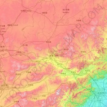
Nombre: Mapa topográfico Zhangjiakou, altitud, relieve.
Lugar: Zhangjiakou, Hebei, China (39.55116 113.81807 42.14716 116.45931)
Altitud media: 1.203 m
Altitud mínima: 21 m
Altitud máxima: 2.759 m
Haz una donación
Otros mapas topográficos
Haga clic en un mapa para ver su topografía, su altitud y su relieve.
Haz una donación
Haz una donación
Haz una donación
Haz una donación
Haz una donación
Haz una donación
Haz una donación