
Haz una donación
Mapa topográfico Qianxi
Haga clic en el mapa para ver la altitud.
Haz una donación
Acerca de este mapa
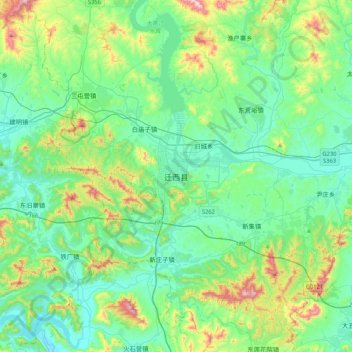
Nombre: Mapa topográfico Qianxi, altitud, relieve.
Lugar: Qianxi, Tangshan, Hebei, China (39.98051 118.14840 40.30051 118.46840)
Altitud media: 196 m
Altitud mínima: 50 m
Altitud máxima: 696 m
Haz una donación
Otros mapas topográficos
Haga clic en un mapa para ver su topografía, su altitud y su relieve.
Haz una donación
Haz una donación
Haz una donación
Haz una donación
Haz una donación
Haz una donación
Haz una donación
Haz una donación
Haz una donación
Haz una donación
Haz una donación
Haz una donación
Haz una donación
Xuanhua District
In the late 14th century, prior to his elevation to emperor of the Ming Empire, Zhu Di ruled his principality of Yan from Xuanhua. Under the Qing, it continued to serve as the seat of a prefecture and was known to the Jesuit missionaries as "Suen-hao-fou".
Altitud media: 945 m
Haz una donación
Haz una donación
Haz una donación
Haz una donación
Haz una donación
Haz una donación
Luannan County
China > Hebei > Tangshan City
Luannan County spans an area of 1,482.6 square kilometres (572.4 sq mi). It has a coastline of 29.63 kilometres (18.41 mi), alongside the Bohai Bay. The Luan River runs through the county. The county's elevation is relatively flat, as it is part of an alluvial plain. However, it is higher in the northern…
Altitud media: 5 m
Fengrun District
The Yan Mountains lie to the north of the district, and the district's elevation generally decreases from the northeast to the southwest. Elevation within Fengrun District ranges from 1 metre (3.3 ft) to 648 metres (2,126 ft) above sea level. The Huanxiang River [zh] and the Dou River [zh] both run through the…
Altitud media: 69 m
Haz una donación
Haz una donación
Zhangjiakou
Lying in between the Mongolian Plateau and the North China Plain, Zhangjiakou has a somewhat rugged topography characterized by high mountains, deep valleys, and rocky pathways. As a result, it serves as a perfect natural screen for Beijing, which has made it a strategic priority militarily since ancient…
Altitud media: 1.203 m
Haz una donación
Baoding City
Elevations in Baoding's administrative area decrease from northwest to southeast. The western parts are dominated by mountains and hills that are generally more than 1,000 metres (3,300 ft) tall; this area includes parts of Laishui, Yi, Mancheng, Shunping, Tang and Fuping Counties as well as the entirety of…
Altitud media: 338 m
Haz una donación
Zhangjiakou
Lying in between the Mongolian Plateau and the North China Plain, Zhangjiakou has a somewhat rugged topography characterized by high mountains, deep valleys, and rocky pathways. As a result, it serves as a perfect natural screen for Beijing, which has made it a strategic priority militarily since ancient…
Altitud media: 1.203 m
Jianshedajie Subdistrict
China > Hebei > Qinhuangdao City > Jianshedajie Subdistrict
Altitud media: 5 m
Haz una donación
Fengning Manchu Autonomous County
Fengning has a rather dry, monsoon-influenced humid continental climate (Köppen Dwa), with long, very cold and dry winters, and hot, humid summers, and the elevation depresses temperatures. The monthly 24-hour mean temperature in January is −10.6 °C (12.9 °F), and in July it is 22.6 °C (72.7 °F), while…
Altitud media: 1.167 m
Qian'an City
Qian'an is located in the northeast of the prefecture-level city of Tangshan, itself located within the northeastern portion of Hebei province. Qian'an is bordered by Lulong County, across the Qinglong River [zh] to the east, Qianxi County to the west, Luanzhou to the south, and Qinglong Manchu Autonomous…
Altitud media: 127 m
Haz una donación