
Haz una donación
Mapa topográfico Bastar
Haga clic en el mapa para ver la altitud.
Haz una donación
Acerca de este mapa
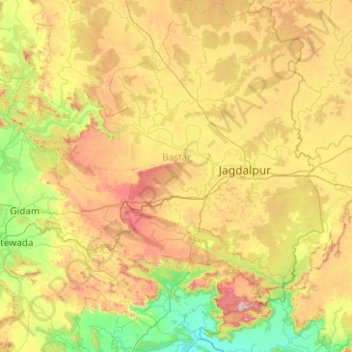
Nombre: Mapa topográfico Bastar, altitud, relieve.
Lugar: Bastar, Chhattisgarh, India (18.59490 81.34576 19.54131 82.24674)
Altitud media: 541 m
Altitud mínima: 213 m
Altitud máxima: 1.180 m
Haz una donación
Otros mapas topográficos
Haga clic en un mapa para ver su topografía, su altitud y su relieve.
Haz una donación
Sukma
India > Chhattisgarh > Sukma Tahsil
It is located at 18°24′0″N 81°40′0″E / 18.40000°N 81.66667°E / 18.40000; 81.66667 at an elevation of 210 m above MSL.
Altitud media: 219 m
Haz una donación
Mahasamund
India > Chhattisgarh > Mahasamund Tahsil
Mahasamund is located at 21°06′N 82°06′E / 21.1°N 82.1°E / 21.1; 82.1. It has an average elevation of 318 metres (1043 feet). Mahasamund is 56 kilometres south-east of Raipur on the junction of National Highway 6 and National Highway 217 close to the Mahanadi River. Mahasamund city is an…
Altitud media: 291 m
Kirandul
India > Chhattisgarh > Kuakonda Tahsil
The Kothavalasa–Kirandul line of East Coast Railway from Kirandul to Visakhapatnam via Koraput is laid through the Eastern Ghats. Up to Araku station, it has many tunnels. Also it pass through the highest elevation Broad gauge station in the Eastern ghats, Semiliguda, just before the Borra caves. Kirandul -…
Altitud media: 742 m
Haz una donación
Pendra
India > Chhattisgarh > Pendra Tahsil
Pendra has an average elevation of 617 metres (2,024 ft).
Altitud media: 594 m
Haz una donación