
Gracias por apoyar a este sitio ❤️
Haz una donación
Haz una donación
Mapa topográfico Mahasamund
Haga clic en el mapa para ver la altitud.
Gracias por apoyar a este sitio ❤️
Haz una donación
Haz una donación
Mahasamund
Mahasamund is located at 21°06′N 82°06′E / 21.1°N 82.1°E / 21.1; 82.1. It has an average elevation of 318 metres (1043 feet). Mahasamund is 56 kilometres south-east of Raipur on the junction of National Highway 6 and National Highway 217 close to the Mahanadi River. Mahasamund city is an important station on the Raipur-Vizag rail route. Mahasamund and Raipur are the only district headquarter cities which are close to the state capital of Chhattisgarh, Naya Raipur.
Gracias por apoyar a este sitio ❤️
Haz una donación
Haz una donación
Acerca de este mapa
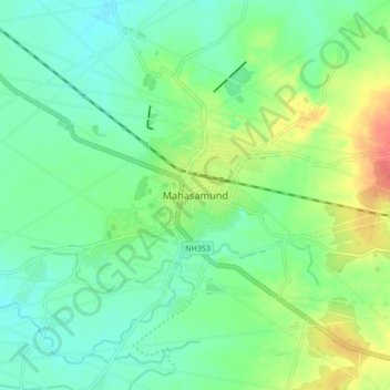
Nombre: Mapa topográfico Mahasamund, altitud, relieve.
Altitud media: 291 m
Altitud mínima: 274 m
Altitud máxima: 325 m
Gracias por apoyar a este sitio ❤️
Haz una donación
Haz una donación